
Updated Feb 2, 2025
In the early 1960s, Connecticut reorganized much of its highway system, changing where many routes were located and how many were funded. This was done in order to repair the fragmentation and disorder in a system that had evolved since 1913.
About 300 miles of state routes were to be turned over to 70 towns; and 400 miles of town-maintained roads from 80 towns would be accepted into the state highway system.
The effects of this reclassification were visible to drivers: about one-third of all publicly signed routes were added, deleted, or changed. Behind the scenes, a few hundred miles of public roads changed hands between town and state, and the system of unposted secret routes was completely revamped.
I call these changes the "Small Renumbering"; compared to the Great Renumbering of 1932, where nearly all highways were renumbered from scratch, the Small Renumbering left most major highways as is. The "Great" and "Small" terms are my own and not official. A better term for the Small Renumbering would be "Route Reclassification."
The state of Connecticut started participating in road development in 1895, with the establishment of its highway department. State aid and oversight gradually increased until a statewide trunk line system, to be improved with state funds, was established in 1913. In 1931 the state started providing funding and engineering for selected town roads as well.
In 1916 the Federal Government started funding roads, adding the foundations of the U.S. route system in 1921 and the Interstate system in 1944.
In 1932, the state established a route numbering system quite similar to today: signed routes 399 and below; and unsigned routes 400 and above.
In 1940, the state started erecting small "State Highway Begins" and "State Highway Ends" signs at those points to aid cities and towns in managing their own road maintenance. Some of these signs may still exist.
In the decades leading to 1960, changes to the state highway system were usually the results of legislative acts. State funding for a highway would often end at a town line or city limit, or another arbitrary location. As the system evolved over four decades, it accumulated over 100 miles of "gaps" in state maintenance, about 30 miles of state highway segments isolated from the rest of the system, and about 150 miles of "stubs," highways where state maintenance would end shortly after the road's start.
In 1955, when Gov. Abraham Ribicoff vetoed a bill that would have added another 4 roads to the state highway system, he explained:
[forcing the state to take over these roads] would lead to a crazy quilt pattern... It doesn't make sense to keep complicating this illogical system... [If this practice is continued, the state would be] log-rolled into such a snarl that we will never be able to work out a constructive system."
Ribicoff also noted that some roads added to the system from legislative bills carried as few as 50 vehicles a day.
By 1960 Connecticut had five classifications of roads: US and state numbered highways, Federal Aid, Town Aid, State Trunk Line, and State Maintained roads. Highway numbering was "for the convenience of the motorist", and a continuous route number did not equate to continuous state maintenance.
In February 1957, a state commission recommended that Connecticut undergo a "complete reclassification of roads," citing discontinuities in the 3,000 mile system still based upon the 1913 legislation. In 1959, the state General Assembly ordered the reclassification. In March 1960, the state hired Edwards and Kelcey, a Newark engineering firm, to make recommendations. Their report was released in 1961.
Edwards and Kelcey cited the primary criteria for classifying roads as the state interest in travel between selected towns, the importance of said towns, and the routes available between them. The firm then proposed three classifications:
The report's recommended system was depicted on a map sheet, without new route numbers. Renumbering was left to the state.
In 1962, the state issued a Reclassification Act following the recommendations in the Edwards and Kelcey report. I believe this is when the Route Numbering and Reclassification Committee was established; a committee that continued into the 21st century. Most road maps started showing the new route numbers in 1963 (hence the URL of this document).
The report included two statewide maps: the existing system (with signed and unsigned route numbers; invaluable for historical research); and the proposed system. Some proposed changes were not adopted, either due to Highway Department decisions or arbitration with the affected towns.
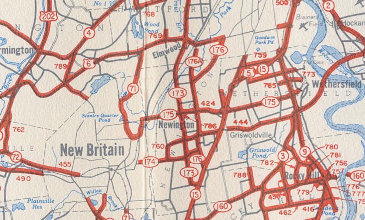 This 1961 map of the existing system in Central Connecticut shows a thicket of state-maintained (but not signed) "secret routes" with high numbers. These were likely added piecemeal by legislative acts. Also note the gaps in state maintenance in New Britain and Hartford.
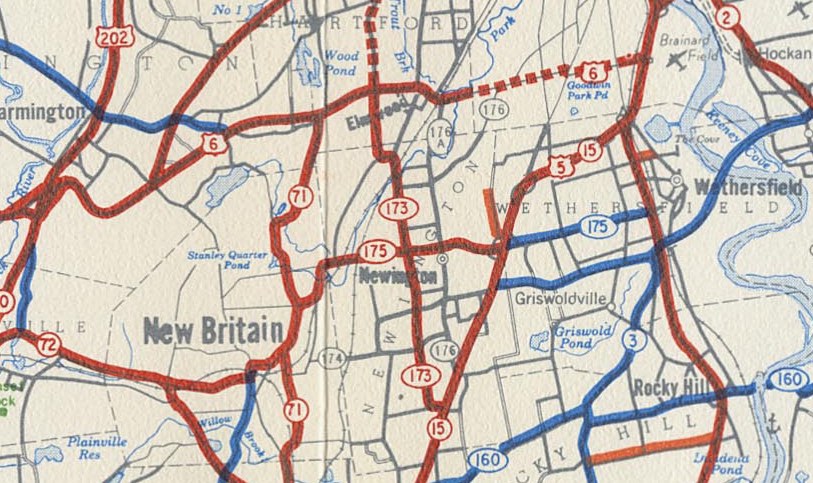 This 1961 map of the recommended system in Central Connecticut shows a less extensive, more coherent area state highway system. Most but not all "secret routes" are removed, as well as minor signed routes like Route 174 and Route 176. Dashed lines are provisional maintenance, to be removed when nearby freeways are completed. Numbers are not proposed here unless routes already exist. Red routes are primary; blue routes are secondary; and orange routes (such as 411, south of 160) are for state parks and facilities.
The state added funding for many miles of town roads, and turned over many routes back to the towns. Several towns opposed certain changes, and an arbitration procedure was established to resolve those disputes. Some changes, notably in the town of Kent, were not resolved until the 1980s.
Even as of Jan. 1, 2007 (the most recent update published by ConnDOT), the following Reclassification Road Transfers from 1961 had not yet been consummated (ConnDOT's term, not mine!):
I'll excuse some "road geek" types for waking up at this point. My primary interest as well was how and why route numbers changed in 1963. But the funding and classification background was necessary to establish context for the rest.
Along with publicly signposted routes (numbers less than 400), the state maintained a system of secret routes, small segments of road with route numbers, but not signposted or otherwise known to the general public.
The route numbering system for secret routes was completely overhauled. Roads belonging to the new Special Service Road classification were given numbers in the 400s. Remaining numbers in the 500s through 800s were assigned by district; for example, District 1 secret routes were numbered 500 through 599. A few pre-reclassification secret routes just happened to reside in the appropriate district afterward and kept their numbers.
Several new non-secret routes were created from formerly secret routes. Most of them were given numbers above 220. The numbers appear almost random on first glimpse: instead of 221, 222, 223, and so on, the numbers were sprinkled about, such as 254, 263, and 316. It turns out there was a method after all; most numbers were chosen to allude to their former secret routes. For example, Route 254 was formerly SR 854, and Route 316 formerly SR 816. Even some new secret route numbers recalled the old ones: SR 485 in Suffield became SR 585.
These signed routes were fully reverted to town control:
These new routes were added, either from old secret routes or town roads:
New state miles were added to these signed routes (not renumbered from others):
Each row is a group of related changes. For example, if a route was deleted, the changed route or new route took over some miles.
| Area | Deleted | Rerouted | Added |
|---|---|---|---|
| New Fairfield | 37A | 39 | |
| Southeast | 119 | 201 | |
| Hartford | 184 | 178, 187 | |
| Easton | 106, 136 | ||
| Weston | 103 | 53 | |
| Ridgefield | 35A | 835 | |
| Branford | 143 | 146 | |
| Ellington | 140A | 140, 286 | |
| Torrington | 4, 25, 72, 179, 116 | 272 | |
| Southeast | 27 | 117, 214 | |
| Hartford | 218, 185 | ||
| Plainfield | 14, 49 | 14A | |
| Woodstock | 171, 190, 197, 198 | ||
| Bantam | 109 | 209 | |
| Roxbury | 199 | ||
| Middletown | 217 | ||
| Somers | 186 | ||
| Enfield | 220 | ||
| N/W Hartford | 9, 189 |
The Edwards & Kelcey report included a map of the recommended state system after reclassification, showing several existing state routes deleted. Here's a list: