Route 10 descends from NE-10, a 1920s "New England Interstate" route established in 1922. Before route numbering, the road between New Haven and Northampton, Mass., was called the "College Highway", as there was a college at each end and several prep schools along the route. Paving on this route was completed on April 28, 1923.
Route 9 was New England Interstate Route 10
The old Route NE-10 entered Connecticut as normal, but instead followed the old Route 9 from Granby to Old Saybrook via Hartford and Middletown, along present-day Route 189, Route 99, and Route 154. This route from Granby south was renumbered Route 9 in 1932.
At the same time, a more vertical Route 10 was created from several former routes. Before 1932, their numbers were:
- New England Interstate route 10 (Mass. Line to Granby)
- State Highway 116 (Granby to Farmington)
- New England Interstate route 3 (Farmington to Milldale)
- State Highway 118 (Milldale to New Haven)
A trip through Old Wethersfield
The original Route 10 through Wethersfield (before 1931) followed Hartford Avenue and Marsh Street into Old Wethersfield, then Middletown Avenue into Rocky Hill, then Main Street to join up with the Silas Deane Highway. The rest of the Silas Deane at that point was shown on the map as "New Trunk Line No. 10." Currently, Old Wethersfield is very quiet, bypassed by three major highways but entered by none.
Early rerouting in Simsbury
Comparison of old maps shows that St. John's Place and Eno Place near the village of Hoskins were an old alignment of Route 10, which used to cross the railroad tracks before intersecting Tariffville Road (Route 315). Road conditions reports in 1937 show relocation taking place here.
Rerouting in New Haven
From the 1930s to early 1960s, Route 10 approached New Haven on Dixwell Avenue, as it does today; but instead of turning west toward Fitch Street, it continued further south. At Dorman Street, the route made a quick dogleg to pick up Sherman Avenue; then followed Winthrop and Davenport Avenues to end at US 1. (This was earlier a part of US 5.)
In 1963, Route 10 was relocated to Fitch Street, Whalley Avenue, and Boulevard, where it runs today. One motivator might have been to better serve Southern Connecticut State College (now University).
Freeway (Expressway) plans
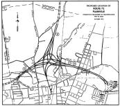
In the 1960s, this interchange of the 10 and 72 freeways with a downtown Plainville connector was planned. Drawing is from 1970. (see
larger image)
Had state plans in the 1960s been carried out, Route 10 would now be a freeway from New Haven to Avon; alternate proposals continued Route 10 to the state line in Granby, or eastward to serve Bradley International Airport and Enfield. A few intimations of these plans exist in contemporary roads, if you know where to look (see "Finding Route 10," next section).
In the 1940s, the New Haven Postwar Master Plan proposed a beltway freeway/boulevard incorporating Route 10 clockwise from Route 34 to Dixwell Avenue, then following Route 80 east into Branford. All I've seen here is an aerial drawing: There are interchanges at Route 34, Route 63, Wintergreen Street, and Route 80. The plan was not implemented.
The state improved Route 10 in the 1930s, but was not yet considering a freeway for the corridor. Grade separations and rudimentary Route 10 interchanges from the early 1930s survive at Route 322 in Milldale and US 6 in Farmington. These were the first such interchanges in the state.
The Milldale grade separation was let to bid in 1930, when the highways involved were New England Interstate 3 and state highways 118 and 111. The motivation was safety — to eliminate sharp turns and other hazards at the intersection.
Connecticut's $400 million Thruway Plan of 1953, which presaged current highways such as I-91 and Route 8, did not include Route 10.
Most documented plans date from the 1960s and 1970s. In 1962, the Tri-State Transportation Commission called for building the Route 10 expressway from New Haven to the Massachusetts state line, to be completed around 1975. In other plans, Route 10 would start at I-95 near Route 122 or use the East Rock Connector to I-91 exit 6. The freeway would continue west of the existing Route 10 into Cheshire, then hop to the east side. At I-84 exit 29 (SR 597), it would join I-84, then exit west with Route 72 into Plainville. About a mile west of I-84, Route 10 would head north on a new freeway toward Avon. Route 10 would have freeway connections with I-95 (possibly), Route 40, I-691/Route 66, I-84, Route 72, a proposed US 44 freeway, and the proposed Route 189 and Route 20 freeways. My Hartford area map shows the approximate Route 10 proposal in the area.
The Hamden/Cheshire and Plainville/Farmington areas underwent more rigorous study (maps, alternate routes, public hearings) than the north and south termini. "Future needs" planning maps showed Route 10 either continuing to the state line or heading northeast toward Bradley.
In 1964, the plan in Granby was to follow the eastern edge of the southern industrial zone (between Route 10/202 and Route 189) with an extension of the Bradley Field Connector (Route 20).
In 1966, the state Interregional Planning Committee advocated building the Plainville - Avon expressway prior to 1990, in part to alleviate projected traffic problems at Cooke's Gap, the New Britain/Plainville shared segment of I-84 and Route 72 through the north-south traprock ridge.
In 1967, the Capitol Region Planning Agency recommended a Route 10 expressway from Farmington north to the state line: "start near the railroad tracks in Farmington, swing to the eastern edge of the Farmington Recreation Association property, return to the railroad, then follow the general line of today's Route 10 from Avon Center to Hoskins Center in Simsbury... [then] along the Granby - East Granby town line, crossing into Massachusetts west of the Congamond Lakes."
Also in 1967, the "Citizens for Farmington" resident group advocated building the Route 10 Valley Expressway between US 6 and Route 4, near the western Farmington border, as part of a plan to relieve traffic on Route 4 by encouraging more use of US 6.
In 1968, Route 10 was proposed as a six-lane freeway from the Route 72 freeway in Plainville (see above for interchange) to Red Oak Hill Road, which would have carried a relocated two-lane Route 4. This was intended to start near Route 72 as soon as the 72/10 interchange was complete, and finish at Red Oak Hill Road by 1980.
In 1974, the state purchased 93 acres of right-of-way in Plainville for the proposed Route 72-10 interchange (see diagram, above). In Dec. 1996, this was turned over to the town, and will probably be used for walking trails and a nature preserve.
Also in 1974, a state feasibility study determined that building a Route 10 expressway south of I-84 was "not considered a prudent or acceptable alternative, considering social, economic and environmental factors."
The state's 1975 Master Transportation Plan recommended three projects north of Plainville, creating a 20-mile expressway from Route 72 to Route 20 in Granby, at a cost of nearly $170 million. Consistent with the 1974 cancellation, Route 10 from Southington to New Haven was not included in the plan.
The remaining Route 10 plans appear to have been abandoned in the late 1970s. Traffic studies were conducted in the late 1990s to address congestion in the Route 10 corridor, but only spot improvements or demand-management solutions will probably be implemented. A section of Route 10 in Farmington was in May 1999 christened a state scenic road, which protects the road from changes that would affect its scenic character.
Finding Route 10
A few highways and ramps serve as evidence of the cancelled Route 10 freeway. I-84's Exit 29, aka "Connecticut's Most-Loved Exit," is actually a short freeway (SR 597), and would have been the north end of the Southington-New Haven segment. In the early 1970s, the state floated a plan to extend SR 597 to the proposed Route 66/ I-691 freeway.
In the south, Route 40 would have connected with the Route 10 freeway, as well as potentially extended eastward to serve the eastern metro area.

