The Mount Carmel Connector
The original planned alignment of Interstate 91 was much closer to the city centers of North Haven and Hamden. To reduce impact to properties and associated cost, the I-91 corridor was shifted eastward before it opened in 1966. To retain access to those cities, the state planned three New Haven-area connectors from I-91 to US 5 and Route 10. These were:
The Mount Carmel Connector would extend north and west from Interstate 91 at Bailey Street in North Haven to Route 10 near Ives Street in Hamden. Initial public hearings were held in 1960.
By 1964, planners had arrived at a location and treatment for the Connector close to what was eventually built. A semi-directional three-level "T" interchange would be built at I-91, with ramps from the Connector to Bailey Street; this was built as planned. A nonstandard interchange involving a divided Dixwell Avenue at State Street was not built as planned; instead, a more conventional set of hook ramps were built at Dixwell Avenue and Devine Street. Dixwell Avenue was shifted slightly south to make room for the freeway. Public hearings were held in December 1965 and October 1970.
A partial interchange was planned at the Wilbur Cross Parkway. There is no interchange at all today: the only place in Connecticut where two freeways cross with no access between them. The original plan would have provided three ramps:
- 40 NB to 15 NB
- 40 NB to 15 SB
- 15 SB to 40 NB
In 1972, the DOT explained why a proposed ramp from CT 15 SB to CT 40 NB was withdrawn:
The location of this ramp is not acceptable from an operational standpoint because of the proximity of three Route 15 interchanges on either side... would result in the unsafe condition of too little distance between ramp termini for drivers to conduct safe lane changing maneuvers.
In 1973, the DOT added:
the removal of [the existing] Route 15 interchanges to permit the addition of a parkway-expressway interchange would not result in any improvement in local service.
A full trumpet interchange was planned at the Connector's terminus at Route 10. The inner loop ramp to Route 10 southbound was omitted, and traffic instead makes a left turn at a traffic signal.
The original route number for the Connector was Route 10. Only after it opened did it become Route 40. I don't know what the plans were for numbering existing Route 10 south of the connector; but the newer Boulevard Bridge section in New Haven (see below) would have been called, of all things, Route 40.
Route 40 opens in sections
The first part of the Connector, from I-91 to Dixwell Avenue, opened in 1972. The state's numbering, SR 724, was not signposted. The remaining 1.8-mile section to existing Route 10, in the design stages, was referred to as the Relocation of Route 10.
On Nov. 12, 1976, the remainder opened, extending SR 724 to Route 10. The state had been referring to the new freeway as the Route 10 connector up until the time it opened. Signs for Exit 10 on I-91 once labeled the highway as "To Route 10".
On Jan. 19, 1977, the state announced that the Connector would become Route 40, in order to provide better route directions for motorists.
New Haven Bypass
The idea of a traffic bypass for New Haven dates to the early 1940s; if a freeway in this role had been built, it might have incorporated Route 40. Even so, in a 1970 public hearing, state officials emphasized: "[the Mount Carmel Connector] has never been considered as part of the long distance expressway system – as the name 'connector' implies."
The first bypass: Route 22
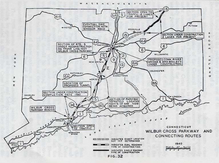
When the Wilbur Cross Parkway (Route 15) was fully open in 1949, there was still no easy way around New Haven to shore points east. Early plans for the area expressway network showed a proposed eastward spur from Route 15 to East Haven; however, that was never built.
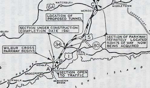
This portion of a map from the 1940 Biennial Report to the Highway Commissioner shows includes a proposed spur from the Wilbur Cross Parkway to Route 80. (
entire map).
To help guide traffic around northern outskirts of New Haven using existing roads, a new numbered route was created incorporating old Route 168 and Route 141, as well as most of Route 139. This new route – Route 22 – was created in 1951, and today zigzags along the modern Route 40 corridor.
Plans for a freeway bypass
Statewide freeway plans in the 1960s included a new highway around New Haven, connecting Route 10 in Hamden to I-95 in Branford. The Tri-State Transportation Council plans called this the Route 22 Expressway. In 1968, when the federal government asked states to nominate additions to the interstate highway system, Connecticut's position was that the the system should not be expanded; however, if it was, the state would nominate a twelve-mile loop around New Haven. This was not granted.
In 1973, the idea of connecting southeasterly to I-95 was still active, but not accommodated in the Mount Carmel Connector design. The plan is not active now.
The other Route 40
In 1970, the state was planning to apply the Route 40 designation to a project, once finished, on Boulevard (now Ella T. Grasso Boulevard) in New Haven: a four-lane bridge, with approaches, over what is now the Metro North railway. The project length was 0.5 miles, while the distance from I-95 to US 1 (the probable extent of a Route 40 designation) was 1.2 miles. The bridge, first requested by the city of New Haven in 1959, would improve access to I-95 and relieve traffic on neighborhood streets. The Route 40 designation would have extended from I-95 to Route 34.
The bridge opened to traffic on Feb. 3, 1978, a year after the Route 40 designation had been given to the Mount Carmel Connector, and the Boulevard itself became part of Route 10.

