
Updated Oct 20, 2018

The Wilbur Cross Parkway is a four-lane controlled-access divided highway leading from the Sikorsky Bridge over the Housatonic River to the Berlin Turnpike north of Meriden. It's part of state route 15. It predates I-95 and I-91, the more heavy duty freeways nearby, by 10 to 15 years.
Continuing southbound across the Sikorsky Bridge is the Merritt Parkway, heading toward New York. Although the Wilbur Cross Parkway shares the Merritt's rural setting, and was designed by the same people, it suffers in comparison to its more famous sister: not as historic, not as scenic, not as charming.
Both the Merritt and Wilbur Cross Parkways were toll roads until 1988. Both prohibit commercial vehicles and trucks.
The most interesting sight along the Wilbur Cross Parkway is the West Rock Tunnel in New Haven: the only highway tunnel in New England passing underneath a land feature. (Boston, for example, has tunnels underwater, under buildings and under the city, but not under a hill.)
Wilbur Cross (1862 - 1948) was a four-term governor of Connecticut (1931-39), a professor at Yale University, the first dean of Yale's graduate school, and a well-known critic of English literature.
As recognition for Cross's support for the Merritt Parkway, its extension toward Hartford was named after him. His name also graces a building at the University of Connecticut, whose growth he supported during his term in office. (At the time, it was called the Connecticut Agricultural College.)
In the late 1930s, work on the Merritt Parkway, from Greenwich to Stratford, was already under way. The inland highway was to turn southeast near Nichols (a village in Stratford), and parallel today's Route 108 to end at US 1, just west of the existing bridge over the Housatonic River.
The 1937 state General Assembly passed a special act placing the Wilbur Cross Parkway on the trunk line system. The road would stretch about 85 miles, from Milford at US 1 to Union at the Massachusetts state line. At this time the route's location and termini were deliberately kept approximate, to accommodate future studies for traffic needs. In addition, the legislature called for a new bridge, called the Stratford Milford Viaduct. (This became today's Sikorsky Bridge.)
In the original Merritt Parkway plan, Washington Bridge on US 1 was planned to carry both US 1 and Parkway traffic. However, the bridge was already recognized as a bottleneck, and planners realized another bridge would eventually be necessary.
When federal funds were made available in 1938, the highway department assembled plans for a new bridge and a new connection to US 1 on the east side of the river. Funding was quickly secured and construction was underway in 1939.
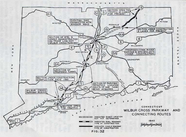
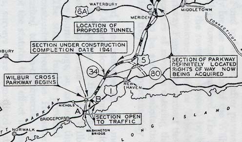 This portion of a map from the 1940 Biennial Report to the Highway Commissioner shows plans and progress from Milford to New Haven to Meriden (entire map).
The Parkway's original definition (85 miles, from Milford to Union), saw some changes as the state accounted for near-term traffic needs and funds available.
Early plans called for two bridges over the Connecticut River, several miles north and south of Hartford, to serve through traffic. In 1940, however, two projects in Hartford and a significant traffic need helped bring about a change in plans:
In response, the highway department added the Charter Oak Bridge and connecting highways to the Wilbur Cross Parkway, and terminated the planned Parkway segment leading from Milford at Meriden. North of there, the Parkway's path would be determined later. Meanwhile, the state would convert a section of US 5 to a four-lane divided highway: the Berlin Turnpike. The Charter Oak Bridge and Berlin Turnpike opened in 1942.
East of metropolitan Hartford, anticipated traffic on the Wilbur Cross Parkway was about half that projected for the western portion. For this reason, the Parkway was built as two lanes only, on wide right-of-way for future expansion.
This eastern section of highway was improved to four lanes in the 1950s, but was never connected to the rest of the Wilbur Cross Parkway and was never tolled.
Between Milford and Meriden, the Wilbur Cross Parkway was built largely as planned. The anticipated extension north of Meriden, as a toll highway leading across the Connecticut River, was never built. Instead the Berlin Turnpike continues north, as well as Interstate 91.
The portion of the Wilbur Cross Parkway east of the Connecticut River, which was never connected to the rest of the Parkway, was in the 1940s renamed the Wilbur Cross Highway.
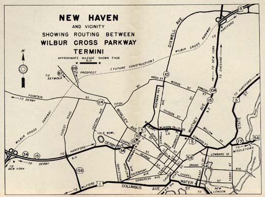 This inset from the 1948 state highway map shows the route between finished portions of the Wilbur Cross Parkway. (The route was completed Nov. 1, 1949). Fun things to note: the old alignment of US 5 (including a 5-10-15 overlap on Sherman Ave.); old Route 158 and Route 114; and two (?) US 5A Routes, on East and State streets.
The Parkway's design was handled by the same team that worked on the Merritt Parkway: W. Thayer Chase - landscaping; George Dunkelberger - bridges; and Earl Wood - roadside development. Construction was intended to progress along the lines of the Merritt work, except for less landscaping, to decrease initial and recurring costs.
In addition, the concrete curbs used for the Merritt Parkway were put aside in favor of three-foot stone shoulders and five-foot sodded shoulders.
But the Wilbur Cross was not just another Merritt Parkway with fewer flowers. Time had passed, and much of the work was done during or after World War II, leading to more functional and less decorative bridges. In contrast to the Merritt's rolling landscape, as it crossed several ridges, the Wilbur Cross topography was more flat (with some exceptions). All in all, it's a much less scenic road, and does not get the same adoration as its sister to the southwest.
The first segment of the Parkway, from the new Housatonic River bridge to Derby Avenue (Route 34), opened on Dec. 24, 1941. The rest of the route suffered from wartime delays.
The Meriden Cutoff segment, extending from Broad Street (US 5) in Wallingford to the Berlin Turnpike, opened Dec. 30, 1946. This alleviated considerable congestion in Meriden.
Another segment of Parkway between US 5 in Wallingford and Whitney Avenue in Hamden opened Nov. 14, 1947. (Some sources incorrectly say Dixwell Ave.)
One segment remained: from Route 34 to Whitney Avenue, including the West Rock Tunnel. In 1948, a special state map inset (see above) guided motorists along local streets to bridge this gap. This segment opened on Nov. 1, 1949, completing a parkway route from Greenwich to Meriden.
The West Rock Tunnel carries the Wilbur Cross Parkway under West Rock Park in New Haven, just north of Routes 69 and 63. The 1,200' dual-bore facility is the only highway tunnel in New England going through a land feature.
The hill at West Rock State Park isn't particularly tall, but tunneling through it proved to be the best choice. Going up the hill would have required tons of earthwork (pun intended) and ruined the park. Going south would have affected developed areas. Going north would have meant more rough terrain.
The tunnel was built in less than a year for $2.5 million; adjusted for inflation in 2003, this is slightly under $20 million. It's hard to conceive of a tunnel being built that cheaply from scratch today.
On June 21, 1939, tolls were added to the Merritt Parkway at the state line, not to pay for its own upkeep (a common misconception) but instead to finance an extension to Hartford. The toll barriers spanned the through traffic lanes, meaning all traffic would stop, pay a dime, and continue; compare this to the Massachusetts Turnpike, where motorists get a ticket at an entrance ramp and pay a calculated toll where they exit.
The tolls were a success: by the late 1940s, a combination of four-lane highways carried motorists from Greenwich, and the Wilbur Cross Parkway, to Hartford.
Tolls were added to the west end of the Wilbur Cross Parkway as well when it opened.
The Merritt Parkway and some sections of the Wilbur Cross Parkway opened without numbered exits: destination signs were the way motorists found their way around. Maps handed out at toll stations helped drivers judge how far they were to their turnoff.
As a response to safety problems caused by last-minute exit choices, exit numbers were added in 1947. Numbering started at 27 (King Street) on the Merritt Parkway continuity with the Hutchinson River Parkway. Instead of lettered suffixes, the cloverleaf interchange at Route 34 was given two exit numbers: 57 and 58.
Along with no exit numbers, the parkways originally had no posted route number, either.
As the state began stitching together a cross-state highway, it was possible to travel from Greenwich to Union on mostly modern, new highway. However, the road changed names seven times, leading to motorist confusion. To help guide the way, the state in May 1948 applied an existing number – 15 – to the entire route, including the Wilbur Cross Parkway.
The Sikorsky bridge, the 1,800-foot open-grate structure crossing the Housatonic River at the Merritt-Wilbur Cross transition, was replaced circa January 2007. In December 1998, the state put to bid a project to replace the bridge, with a six-lane structure (four thru and two operational) including a bike path/walkway on the north side.
Most drivers don't lament the old slippery steel grate surface of the original bridge; however, ConnDOT said the primary reason for replacing the bridge is the eroding steel in the support structure. In Nov. 2003, a ConnDOT representative said the 1940 bridge is in "good shape, but functionally obsolete for the traffic it carries."
In November 2000, the contract was awarded to Balfour Beatty Construction, Inc. of Atlanta, Ga. for $83.7 million. In November 2003, the first span opened and traffic was shifted to it, clearing the way for the old bridge to be demolished.
An obscure urban legend (or "suburban legend") is the idea that the steel grate was mistakenly designed or installed upside down; but there's no truth to that.
Traffic congestion in Fairfield County, and the huge expense of adding lanes to I-95, has led some lawmakers and lobbyists to explore allowing trucks on the Merritt and Wilbur Cross Parkways. The state legislature's transportation committee and the state Transportation Strategy Board oppose this, for some good reasons: many overpasses are too low for full-size trucks and would need to be replaced; and safety and scenery on the parkways would suffer.
"But the Cross, built in the post-World War II era, lacks the Merritt's rural ambience and whimsy. Although the Merritt team was reassembled - W. Thayer Chase did the landscaping, George Dunkelberger designed the overpasses and Earl Wood oversaw roadside development - they seemed less inspired."