In the 1920s, State Highway 117 followed today's Route 34 between New Haven and Route 8 in Shelton.
Old Route 117, Northwest
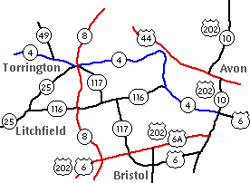
In 1932, the old Route 117 was created, connecting Plymouth to Torrington along where Routes 72 and 4 go now. Here's a map:
On May 1, 1954, that route became part of an extended Route 72.
New Route 117, Southeast
In 1963, the modern Route 117 was created, extending from state route 95 (now Route 184) to Route 2. A small part of it (the Col. Ledyard Highway portion) had been part of Route 27, from 1950 to 1963. The Center Groton Road portion was SR 588 between 1959 and 1963.
In November 1963, the state proposed (once I-95 work was complete) to extend Route 117 south to US 1, to create a continuous route from US 1 to Route 2. In 1964, Route 117 was extended south to US 1.
Bluff Point Connector
In the early 1960s, the state planned to create a state park at Bluff Point in Groton; and, as done with Rocky Neck and Hammonassett state parks, create an expressway connector to it from I-95. This was discussed in 1961, and a state highway bill in 1967 called for $1.3 million in funding for the connector. (The state purchased the park land in 1963.)
In February 1968 a public hearing was held. The proposed highway, an extension of Route 117, would be about two miles long, and "at least four lanes wide with a median divider separating lanes at several locations." It would cross US 1 at grade, but overpass Industrial Drive. It would also claim 32 homes from the Fort Hill housing development.
In May 1968, Groton officials countered with their proposed route: a new highway diverging from Route 117 at Old North Road, and generally following that alignment, overpassing US 1 and Depot Road. The city opposed the state's at-grade intersection with US 1 and its path through Fort Hill Homes.
In 1970, the city and state continued to disagree on the best route for the connector. City officials said the single-purpose state plan, straight from I-95 to the park, was not in Groton's best interests; a new city proposal, an east-west route, would serve Trumbull Airport and the park, and relieve traffic on US 1. In late 1970, the state agreed to delay further planning until the next session of the General Assembly.
On Sept. 30, 1971, Gov. Meskill ordered a new study of the park as a whole, including access to it. A few years later the connector proposal died. I haven't seen a specific date, but news stories about it dry up in 1973. The road is still included in the Master Transportation Plan in 1975.
As it turned out, the topography and vegetation at Bluff Point was found to be too fragile to support large-scale recreational activity. Today, access to the bluff is only by foot, or non-motorized vehicle.
Route 117 freeway once studied
In 1970, the state was studying an expressway or freeway option paralleling Route 117 to handle traffic between I-95 and Norwich / Route 2A. I haven't heard about this since.
Route 117-164 connector once studied
In 1979 and 1983, the Southeastern Connecticut RPA called for a new highway link northeasterly from Route 117 to meet Route 2 at the terminus of Route 164; this link (to date unbuilt) would have created a continuous 117/164 highway from Groton to Griswold. The highway would have incorporated a realigned Church Hill Road.


