
Updated Aug 28, 2025
If you want to skip the history, go directly to the list of all secret routes I've found. I provide more background on some prominent ones in the 400s, 500s, 600s, 700s, 800s, and 900s.
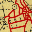 Network of old secret routes, along with CT 3 and 160, Rocky Hill. Connecticut official highway map, 1941.
"Secret" routes are stretches of state-maintained road given route numbers for tracking purposes. They are not signposted or shown on the official tourist map. The typical secret route could be a long exit ramp, a road leading to a state park, or a connector road to publicly numbered routes. Some routes are even temporary: on the logs for a year or two during construction, then turned over to town maintenance. In the past, some secret routes, like SR 611 in Stafford, have been promoted to signed routes (like Route 319).
Connecticut has over 200 secret routes; most are less than a mile long.
Secret routes are numbered in the 400s through 900s. Signed "non-secret" routes are numbered in the 300s and lower.
The official name for these routes are State (or special) service roads (SSR's), and State roads (SR's). As of the 1962 route reclassification, the DOT uses this numbering convention:
Even if a state district changes boundaries, the affected routes are not renumbered; that's why some towns have a mixture of routes.
As they're not signposted, secret route numbers can be quickly reused: SR 724, for example, has been used for a road in Canaan, the Mt. Carmel Connector, a bridge in Bridgeport, and the Oak Street Connector in New Haven.
 Arrow, "Putnam - Danielson," undated; National Geographic, Road Atlas, 2000; Rand McNally, Road Atlas, 1996.
If the "secret" route numbers were only known to DOT employees, they wouldn't be of much interest. Fortunately for road geeks, the secrets leak out now and then.
Connecticut DOT news releases often mention SR's and SSR's, which some newspapers obligingly print without considering why these routes never seem to be signposted. "Route 730" in Wallingford (now part of Route 68) made several headlines in the 1960s.
Some politicians, privy to the maintenance details of roads in their towns, may even lean into the "secret" aspect:
Some of you may be surprised to learn that Cross Highway [SR 817 at the time] is a state road. It is a state road but the State of Connecticut's Department of Transportation doesn't want you to know that. They refuse to post it as a state road and no wonder. Cross Highway is in deplorable condition...
Actually, from the schoolhouse to the state line, this winding road is still a state highway, though the number is kept from public view, apparently in an effort to prevent the State Highway Department from getting too much grief for its terrible condition. This segment of the road, however, bears the official state route number, 835.
My own hot take: people will complain, but secret routes are useful. The state maintains important roadways, however short, while keeping inventory using numbers; but avoids cluttering roadways and maps with those numbers.
The internal DOT maps of each town mark all routes, including secret ones (though not the 900s, often), and commercial maps seem to pick a few up from there. Given Rand McNally, Arrow, and Gousha maps (pictured), you would really expect to find a Route 664 in Killingly; but you won't, because there are no signs for it.
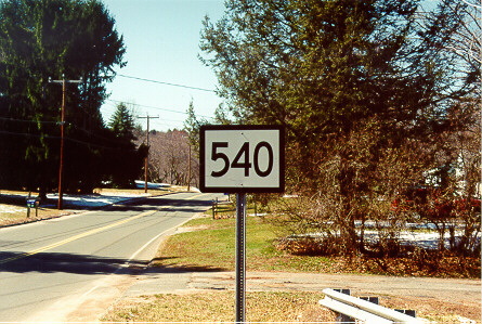
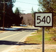 Reassurance marker blew the cover for SR 540 in East Granby. (Photo from anonymous contributor.) (larger photo)
Secret routes are not supposed to be signposted, but human fallibility dogs the DOT as much as other agencies. At least three secret routes have also seen the light of day, however briefly.
One was an SR 771 sign Tim Parry once sighted in Fairfield. (It's now part of non-secret Route 130.)
The second is SR 540 (Hatchett Hill Road), near its intersection with Route 187 in E. Granby. (In late 2004, the sign was taken down; it had been improperly specified by a consultant on an earlier project along the road.)
The third was the high-profile leak: a big green freeway guide sign in Vernon. If you drove I-86 (now I-84) there in the early 1980s, you might have seen the short-lived sign for Route 533, Tunnel Road. This was during the I-86 reconstruction and it appeared that someone goofed in the sign department. To a teenage roadgeek (me) this was amazing to see, and when it was corrected (to plain "Tunnel Road") I felt a brief wistful sense of loss: a sign that couldn't be allowed to stand because it was different.
State-maintained roads without posted route numbers date back more than 100 years. For example, Dividend Road in Rocky Hill, linking what is now Route 99 to a booming industrial area near the Connecticut River, was on the state map in 1923, but without a number. If the state had a numbering system for "secret routes" at this time, I haven't found it yet.
 Connecticut's 1925 highway map shows several "secret routes" at the time – state aid roads (green) without numbers. Dividend Road, for example, is the southernmost green road in Rocky Hill. If you're feeling lost, Route 111 is now Route 66, and Route 17 became "before it was a freeway" Route 2.
Also, some state aid roads were given numbers (usually in the 300s) but not signposted, while other 300s routes were signed. This was not a separate numbering system like the one in use now.
In 1932 the state renumbered most of its highways, dropping its organically-grown system of routes in the 100s and 300s in favor of signed routes from 2 thru 399 (all but two of them within 2 to 216). More than 100 state roads without posted numbers were given internal numbers based on the district they were in. With 11 districts, the numbers above 400 were divided into blocks of 50:
Our example of Rocky Hill's Dividend Road, in District 8 (750-799), was given the number SR 753.
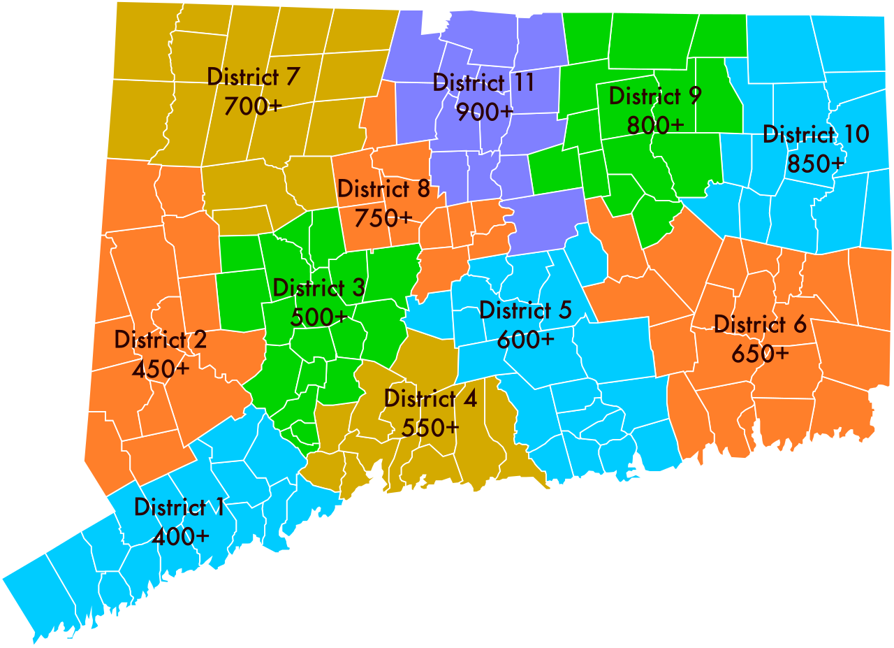 Connecticut's 11 highway districts, in 1932. The initial set of "secret routes" were allotted to these districts as shown.
That numbering system remained through 1936. In 1937, however, the state began assigning new available numbers in the 400s, regardless of location. In 1939, the only newly assigned SR numbers were consecutive, from 430 to 449. The geographic-based numbering system was over.
At some time before 1949, the state consolidated its 11 districts into 8; and in 1949, further combined those into 4. The numbering system leading up to 1960 was less systematic:
In the early 1960s, the state reclassified the highways in its system. It took a few years of negotiations with towns over maintenance transfers for (most of) the dust to settle. Eventually, all retained state roads and special service roads were renumbered to fit the district-based system at the top of this page (for example: SR 864 in Plainfield became SR 664). A lucky few roads, like SR 509, fit the old and new systems and could keep their numbers.
Our example of Dividend Road, SR 753, was removed from the state highway system and is now locally maintained.
Some towns contested state decisions on certain roads, and some routes remained under arbitration for several years. Kent's Macedonia Road, for example, was slated to revert to the town in 1962; however, it remained SR 477 until 1987.
More than 400 different secret routes have been defined over the years. As of 2024, 225 still exist; the newest, introduced in 2024, is SSR 495 in Meriden, serving a DOT maintenance facility. My list has mileages, short descriptions, and history where available.
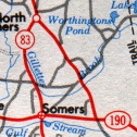 SR 528, connecting CT 83 and CT 190 in Somers. Connecticut official highway map, 1977.
You can still find secret routes on maps, but the detective work can sometimes be daunting. Sometimes motorist maps will leak the route numbers, as in the SR 664 example above.
For current secret routes, the best source is the CT DOT site:
The official state tourist maps have rarely shown secret route numbers, but often showed where the routes went, since they are state maintained roads. The 1940s maps show the routes (but no route numbers); they're the roads drawn red without route numbers. Since the early 1970s, all official paper maps have done this (see figure). Any unnumbered red road is a secret route.
I've collected these routes from official Connecticut highway logs, town maps, state highway department documents, and commercial maps that have blown their cover. Before I had found these sources, however, Neil Kelly provided me dozens of street names from maps he found, and Paul Schlictman added "dates spotted" for several other routes. Hats off to them both.
Also:
From time to time, assembly acts have called for adding more local roads into the state highway system; most of these small roads would have become secret routes if actually admitted. This will eventually become a separate page, but here's a very incomplete list:
For information about specific secret routes, see the complete list (terse entries; mileage, location, and dates), and more details for the more prominent routes.