Route 131 follows the Quinebaug River valley from Sturbridge, Mass. to Thompson, Conn. It intersects a few Connecticut-bound routes while in Massachusetts: I-84 (indirect, with signage from I-84); Route 198; and Route 169.

Updated Oct 20, 2018
 |
|
In the 1920s, State Highway 131 followed today's Route 37, Chimney Hill Rd and Briggs Hill Rd in Sherman from US 7 to the New York state line.
In 1932, a new Route 131 was created along what is now Route 199 in Roxbury, including the old Route 199 south of Route 67. Route 131 south ended near Roxbury Falls (the waterfall itself) at the old village of Shepaug. At the same time, the Route 199 designation existed along today's US 44, west of US 7.
In 1935, the Roxbury Route 131 became Route 199; and modern Route 131 was created in Thompson, replacing a state-maintained but unsigned route (SR 874), and connecting to already-existing MA 131.
Route 131 is rare in that its number, adopted from Massachusetts, dates back to the route numbering system in the 1920s. The only other state routes that do this are Route 8, Route 10, Route 12 and Route 32 (from the New England Interstate system); and Route 101, which also survived but was relocated when US 44 was created.
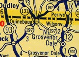 In this 1934 Texaco map (Rand McNally), Route 197 east leaving Quinebaug seems to take two directions.
In the 1934 road map shown, Route 197 crosses 131 just south of the state line, but then continues as two Routes 197, like a ray of light reflecting and refracting off a liquid surface.