In the early 1960s, Groton was the uncontested submarine capital of the world. The borough employed over 20,000 people in industrial and military jobs: primarily submarine manufacturer Electric Boat and the U. S. Navy. More than half the region's manufacturing jobs were here, concentrated in a small area facing the Thames River, south of the Gold Star Bridge (US 1; now I-95). Most workers were making two trips a day between the Borough and US 1, on a series of congested local streets the state maintained and called State Road 649 (created in 1962).
SR 649 started at I-95 exit 85 (just east of the Gold Star Bridge), an interchange that was once complete but now only provides access to and from the west. The route then followed North Street, Mitchell Street and Benham Road southward to Avery Point. The multiple urban intersections and lack of access control made this a nasty commute, and by around 1960 the city, employers and workers were calling for an alternative. The state drew up designs for a relocated SR 649 connecting to the planned I-95.
A Popular Highway
In August 1963 the state held a public hearing at a Groton junior high school near the proposed highway. Interstate 95 had already been designed, and would open the next year. The SR 649 approach to I-95 had also been fixed: this is the section of today's Route 349 between US 1 and I-95. The 1963 hearing was to discuss the continuation of the route west and south.
The proposed 649 is basically what Route 349 is today: an expressway from I-95 through an interchange with US 1; an at-grade intersection with Meridian Street; a limited-access section heading south, overpassing Poquonnock Road, and intersecting Rainville Avenue. The relocated 649 would follow Rainville Avenue west to Eastern Point Road.
After reading a series of transcripts of acrimonious public hearings for other highways, I was surprised to see the warm response given to the SR 649 relocation. Here's how the comments shaped up:
- Groton Town Manager Alfred S. Harding: in favor
- Groton Town Council, by earlier unanimous vote: in favor
- Borough Warden Robert Toher: in favor
- Southeastern Regional Planning Agency: in favor
- State Rep. Fred Little, Groton: in favor
- State Sen. Morgan McGuire: in favor
- [state?] Rep. Ray Holdridge, Ledyard: in favor
- [state?] Rep. Mary Boatright, Stonington: in favor
- Groton Chamber of Commerce President Clarence B. Sharp: in favor
- Sen. Thomas Dodd: in favor
- Frank Dickson, Norwich Chamber of Commerce Executive VP: in favor
- citizen T.: would like it shifted west
- J. William Jones Jr, President, Electric Boat: in favor
- John Weimer, President, Metal Trades Union (EB workers): in favor
- Pfizer employee Robert A., on behalf of the company: in favor
- citizen Edwin A.: in favor
- citizen Kevin W.: the route is badly laid out and favors Rhode Island traffic
- citizen Blake R.: had some questions
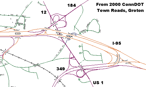
Complex interchange group along I-95 in Groton. How would you redesign this?
One note of dissent brought up was the location of the 649/I-95 interchange, which is skewed to the east, away from New London. The Highway Department stated the main culprit here was the very complex interchange situation created by the new I-95 among the convergence of old Route 84 (now Route 184), Route 12 and US 1 at the same point (see above for the way it is today).
There was no room to connect the planned highway closer to the Gold Star Bridge without either a complicated multilevel interchange right at I-95/Route 12, or significant loss of property at an interchange further west.
The Relocated SR 649
The highway opened on Nov. 3, 1966, a couple years after I-95 was completed, and was for some time called the Defense Access Highway. In 1977, SR 649 was relocated to turn east at Rainville Avenue, and follow Poquonnock Road south of the Groton - New London Airport to end at US 1. Shennecossett Road and Thomas Road were turned over to the town. The remaining route to Avery Point was renumbered SSR 440.
In 1977, a Groton city councillor was asking the state to widen the Defense Access Highway; employment at Electric Boat and Pfizer were higher than when the highway was designed. However, funding issues prevented the state from taking this up.
On June 1, 1985, the state assigned a posted number – 349 – to the portion of SR 649 and entirety of SSR 440 leading to Avery Point. The state's reason for this was to encourage trucks to use the route instead of the Bridge Street I-95 exit and city streets.
The rest of SR 649 near the airport remains to this day.
The highway was also renamed the Clarence B. Sharp Highway, after the former Groton mayor, when he died in 1974.
Who was Clarence B. Sharp?
He sounds like a jazz musician -- woodwind, perhaps -- but the late Clarence B. Sharp was the president of the Groton Chamber of Commerce when the highway was designed, and may have had an early role in advocating it. Later, he became mayor of Groton.
At the August 1963 public hearing was some droll interplay between Mr. Sharp and presenter David Johnson, Connecticut Highway Dept. Director of Planning and Design:
MR. SHARP: Mr. Johnson, I had a call from Mr. Henry Lucas.
MR. JOHNSON: Excuse me, this is Clarence Sharp.
MR. SHARP: I'm sorry, I thought everybody knew me. My name is Clarence B. Sharp, and I'm President of the Groton Chamber of Commerce...
It's not likely either one foresaw Sharp's name eventually appearing on the big green guide signs on I-95.
Sharp also figures into another chapter of Connecticut road history: he once proposed an underwater tunnel across Long Island Sound, connecting Orient Point to East Lyme near Rocky Neck.
Route 349 Today
It's tempting to recommend an interstate spur numbering, such as I-795, because Route 349 is a clear example of such a spur. But there's less demand for the highway now than there was in the 1960s; manufacturing employment has shrunk, and today's traffic problems arise from different reasons (tourism) and affect different areas (such as Routes 2 and 11).


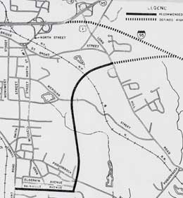 SR 649 relocation plan map, 1963.