The Cornwall area in this 1949 state map shows the old alignment of Route 63 near Route 43.
Commissioned in 1932, Route 63 has grown a few times to nearly double its original size. Originally, it extended 27.34 miles, from Route 67 in Woodbridge to Route 61 in Morris.
In late 1931, the state's plan was to have Route 63's north end in Middlebury, at the eastern intersection of today's Route 64 and Route 188.
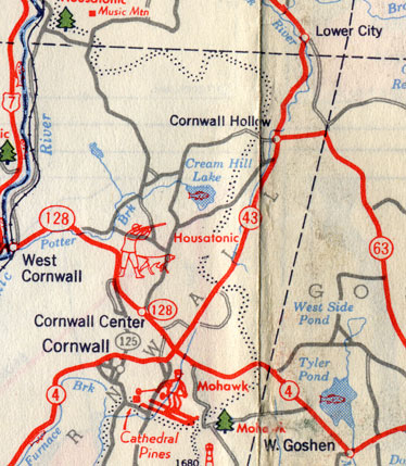
In 1943, Route 63 was extended north, replacing part of Route 61, to reach Route 43 in Cornwall, for a new length of 43.37 miles. Its alignment at the north end differed from today's: at the Goshen - Cornwall town line, Route 63 followed Hautboy Hill Road westerly, to end at Route 43 in the Cornwall Hollow section of Cornwall (see map scan at right).
The Hollenbeck Road segment of today's Route 63, leading to US 7, was improved in 1951, and was designated part of Route 63 on Sept. 11, 1951. Hautboy Hill Road is now locally maintained.
Also in 1951, Route 63 was officially extended along part of Route 43 and all of Route 126 to end at US 44 in Canaan, for a length of 52.62 miles. I don't know if this extension had a chance to be signed, but the plan was announced to the public in September 1951, with the intent to create a continuous route from Woodbridge to Canaan.
In 1952, the former Route 126 portion was returned to Route 126, leaving Route 63 to end at US 7. Route 63 was now 47.74 miles long.
On May 1, 1954, Route 63 was extended south from its terminus with Route 67 in Woodbridge, to overlap with Route 67 along Whalley Avenue into New Haven. The Route 63/67 southern terminus was now Sherman Avenue (Route 10 at the time). Route 63 grew to 53.40 miles long.
In 1962, Route 63 was moved from Church Street to Meadow Street in Naugatuck.
Circa 1963, Route 63 was extended south along an overlap with Route 10 along the Boulevard, to end at US 1 in New Haven. A state Special Act in 1967 (SA 67-315) even refers to the planned Boulevard Bridge over the Metro North railroad tracks as the "Route 63 Extension." This extension was removed in 1976, leaving Route 63 at its current southern terminus with Route 10. (The Boulevard Bridge opened in 1978 as part of Route 10, so Route 63 never extended as far south as I-95.)
In 1965, a project to relocate more than 2 miles of Route 63 in Waterbury, Middlebury and Naugatuck went to bid. This was completed around 1968. The result was the 2.3 miles of limited access 2-lane highway, from Country Club Road to Field Street. At the intersection with Route 188 in Middlebury, you can see (from aerial photos) the older alignment of Route 63, to the east of the current roadway. The road is not marked on current maps, and may be inaccessible.
Around 1968, Route 63 was realigned near Route 42 in Bethany; in other words, the Straits Turnpike made straighter. Grant Road and the short segment of Litchfield Turnpike are part of the old alignment. In the 1970s, Grant Road was even called "Old Rt. 63."

