Commissioned in 1944, Route 21 was originally a 3.78-mile connector from Route 12 to US 44. Part of this route, Converse Road, had already been added to the state highway system in 1936 as SR 856.
In 1955, Route 21 was extended another 1.89 miles north to Route 193.
In 1963, however, it appears the state wanted to extend Route 193 southward and absorb Route 21. The ConnDOT spreadsheet shows this happening that year, and no record of it being rescinded; but a look at a highway log or map shows that Route 21 survived that proposal.
A possible, but not certain, early Route 21
In November 1931, some erasures give clues to earlier proposed route numbers.
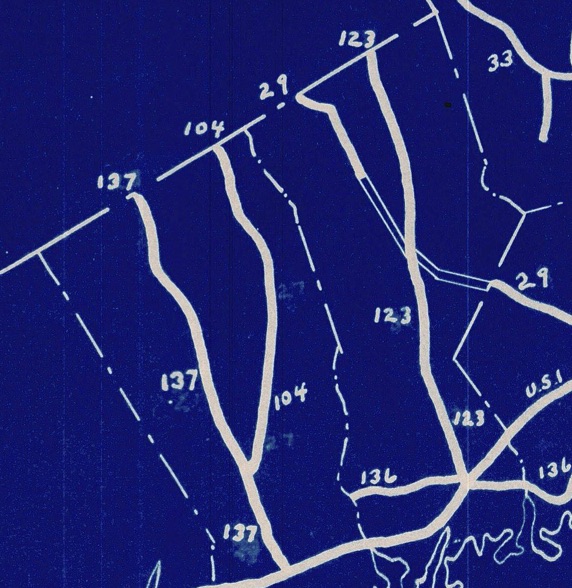
On a November 1931 planning map, some interesting erasures hint at early proposed route numbers in the southwest. The state came up with a mostly geographical clustering of north-south routes, from Route 29 (now Route 124) in Darien and New Canaan to Route 95 (now Route 49) near the Rhode Island state line. However, there were clear plans for Route 137 to be called Route 27, and for Route 104 probably to be Route 23. Both Route 23 and 27 were dropped in favor of numbers that matched routes in New York. What if Connecticut's original numbering plan started not with 29, or even 23, but 21?
It's not shown on the map, and there's no proof yet, but a Route 21 could have been set aside for Greenwich. Before 1932, a Route 358 had followed North Street; and in 1960, the state had contemplated two north-south surface routes in that city.
This could explain why Route 21 appeared later, far out of place, in the northeast part of the state. The number was no longer planned for Greenwich and was available.
This map (and the 1932 state map) have routes 104 and 137 switched, which is likely a mistake and was not signed that way. The numbers match their New York counterparts, which were not switched.

