In the 1920s, the number 3 was used for NE-3, a precursor to
US 6 in New England. The section of present-day Route 3 between Route 66 and Route 372 was called State Highway 346; the road north of there was not numbered. In the Great Renumbering of 1932, SH 346 became part of Route 72.
The Shunpike: Original Route 3
The original alignment of Route 3 (Shunpike Road, Cromwell Avenue and Maple Street) was not added to the state highway system until 1936, when it became unsigned SR 754. In 1940, SR 754 became Route 3, a 7.53-mile route extending from Berlin Road (Route 72 at the time; now SR 524) in Cromwell to Middletown Avenue in Wethersfield, two blocks east of the Silas Deane Highway (Route 9 at the time; now Route 99). Middletown Avenue had served as part of Route 9 until about 1930, when the Silas Deane Highway opened. At the time Route 3 was created, Middletown Avenue was already a local street.
The name "Shunpike Road" evokes a time when bypass routes were created to avoid toll stations on turnpikes; and in the 1940s, Route 3 seemed mainly a way to travel north and south without using the old Route 9 to the east. It would not have been a surprise, in 1940, to see it designated Route 9A. It was a surprise (to me) that a major single-digit number (3) was assigned to a very minor road.
The Putnam Bridge, I-491, and I-86
One of Connecticut's original planned interstate highways in 1957 was Interstate 491, a southeastern connection between I-91 and I-84 through Glastonbury and East Hartford. On Dec. 31, 1958, the north span of the Putnam Bridge opened, half of the planned eight-lane, dual-span structure. (The other span was never built, and four lanes of traffic share the single span.)
William H. Putnam, for whom the bridge is named, was chairman of the late 1950s Greater Hartford Bridge Authority. Sadly, he died nine months before the bridge opened.
Along with the missing span, freeway connections on either side were omitted: getting to either Interstate 91 (which opened later) or Route 2 required detours on local streets. Both sides were improved in the late 1980s and 90s (see below).
Route 3 was extended from Wethersfield to Glastonbury, incorporating the bridge and approaches, for a new length of 10.87 miles. This was expected to be a temporary numbering; once the freeway was extended through East Hartford to I-84 in Manchester, it would be designated I-491. In late 1968, when I-84 toward Boston was redesignated as I-86, the proposed I-491 would have been part of I-86 as well.
However, local resistance to yet another freeway in East Hartford helped kill the I-491/86 project. In 1973 I-491 federal funds were traded in for US 6 improvements east of Willimantic, the Route 9 freeway between I-91 and I-84, I-691 to the south, and the proposed I-284 and I-484.
A 1956 article in the Hartford Courant noted that approaches to the bridge from the Berlin Turnpike were planned. I have not seen more details about that.
Improved connections: the Route 2-3 Connector
Despite seeing its interstate ambitions thwarted, Route 3 has enjoyed enhancements on both sides of the Connecticut River. For the first 28 years, northbound travellers leaving the Putnam Bridge met a tollbooth and a traffic light on Main Street in Glastonbury. Getting to Route 2 required another quarter-mile on local streets, to the old Exit 5D interchange at the East Hartford city line. The 2 west to 3 south connection was even worse: signs directed you off Route 2 at Route 94, followed by a 3-mile trek along Hebron Avenue and Main Street.
After I-86 was cancelled in 1973, the proposed highway link was called the Route 2-3 Connector. Alternative plans in the 1970s included:
- a freeway connector with a half-interchange at Main Street (access to and from Wethersfield only), in 1959
- a freeway connector with full interchange at Main Street
- a boulevard with traffic signals instead of a freeway (1970s)
- a freeway connector with ramps to Forbes Street in East Hartford
Generally, Glastonbury officials preferred the full freeway with the full Main Street interchange, and East Hartford officials favored the smaller-scale boulevard, especially without any connection to Forbes Street. In 1978, the East Hartford mayor demanded that the DOT first build I-284 and the I-84/I-86 (now I-84/I-384) connector before building the Route 2-3 connector. In 1984, when a plan without the Forbes Street link was announced, East Hartford still opposed the project, saying Glastonbury was shifting its traffic issues onto East Hartford streets.
In 1987, full interchanges at Main Street and Route 2 were built. The old Exit 5D interchange was dismantled, and the Route 2/3 interchange took that exit number. A pond in the loop ramp at routes 2 and 3 occasionally features skaters in the winter and plastic flamingoes in the summer. An anonymous letter to the Hartford Courant claimed the flamingoes were a protest again the destruction of natural wetlands during the interchange's construction.
When the Putnam Bridge opened, a ramp from Route 3 southbound to Naubuc Avenue was included. In the 1970s, this ramp was made two-way, so that Naubuc Avenue traffic could enter Route 3 southbound. This ramp was removed when the full connector to Route 2 was completed, as ramps for Main Street provide the same connections.
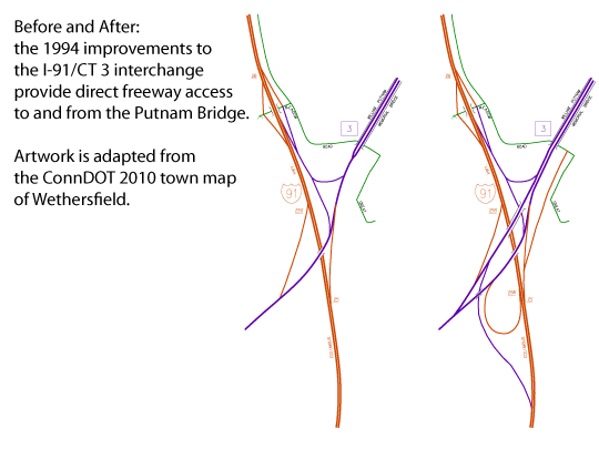
Improved connections: the Route 3 / I-91 interchange
On the Wethersfield side, travellers leaving the bridge also dealt with detours: to get to I-91 southbound, they first had to get on 91 north, then take the next exit and get back on 91 south (see above). The interchange was left incomplete because of: financing difficulties (the project combines a toll bridge and interstate highway, with different federal matching); and the proposed I-491 and a second Putnam Bridge span that were coming through Real Soon Now. By 1973, however, it was apparent that neither I-491 nor the second span would materialize.
In October 1994, a nearly full freeway-to-freeway interchange with I-91 opened, except for the 91 north to 3 south and 3 north to 91 south ramps (see above). As it turns out, those movements are fairly well served by Route 99 and its interchange with I-91 to the south. Parts of the new interchange had opened earlier:
- October 1993: loop ramp from I-91 south to Route 3 north
- August 1994: combined Exit 25-26 ramp from I-91 north to Route 3 north and Great Meadow Road
The interchange geometry, including the large loop and left exits on Route 3, is close to the 1960s plans for completing it. Left exits were already deprecated by the 1990s (two future (in 1969) left exit ramps at I-91 and Route 9 were built as right-exit ramps in 1989). However, space constraints at the foot of the Putnam Bridge made right-hand exit ramps from Route 3 more difficult to fit in.
In late 2001, Route 3 was also widened to four lanes (undivided) from the I-91 interchange to the Silas Deane Highway (Route 99). Spring Street and Middletown Ave were rerouted to meet Route 3 in a single four-way intersection, where Route 3 now has left-turn lanes.
A few miles inherited in Cromwell
On Dec. 21, 1989, Route 9 was extended from I-91 in Cromwell to Route 72 in Berlin, sparking a number of route changes in the area. Route 72 became Route 372, and the state took the opportunity to extend Route 372 along West Street (SR 525) to Route 99 instead of following Route 72's 90-degree turn to Middletown. The north-south part of old Route 72 was given to an extension of Route 3, giving Cromwell a simpler, more orthogonal highway layout.
See the old Route 18 (an older designation for West Street) for a map.
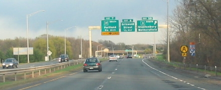
A low-quality "at the wheel" photo shows the orange "A" sign denoting a bypass around Hartford. Location: CT 2 eastbound at CT 3. Photo taken 2004 by Kurumi.
Route A
From 1992 to about 2008, Route 3 was part of a marked alternative route to I-84 through Hartford. "Route A" did not exist in the state highway log, but was signposted along existing highways: I-691, I-91, Route 3 and Route 2. DOT officials said that, even when all highways were free-flowing, using Route A took only 2 to 5 minutes longer.
Recently, however, "A" signs have been replaced; see Steve Alpert's CT 3 photos page for an example of this.
Widening in Rocky Hill and Cromwell
The former shunpike serves enough traffic in the area around Route 160 and West Street (SR 411) that required widening to four lanes around the late 1980s.