The Map Inside: Connecticut Officials: 1963
This exhibit shows how the Connecticut official tourist map has changed since the 1930s. You can start with the introduction or browse year to year. The scans may not be actual size (150 dpi), but are consistent with each other.
Other years:
1930
1934
1935
1938
1941
1942
1943
1949
1952
1955
1956
1957
1959
1960
1961
1963
1965
1971
1972
1975
1989
1998
2000
2001
2002
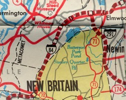
In 1963, the state highway department started producing its maps in-house. The statewide map kept this distinctive style (fonts, colors, lines) until 1989. In my opinion (but I'm just one guy) this was the golden age of Connecticut's maps.
Skirting New Britain is a sight familiar to most state residents in the 1960s and '70s: proposed expressways as dotted lines. Some were never built and simply disappeared off later maps. But I-84 did open in 1969, and much of the proposed I-291 opened in 1992 as part of Route 9.
The city inset style saw some revisions in the 1960s maps. Red markers for interstate highways (such as I-91) became black. From 1963 to 1967, city insets were on the "back" of the map, opposite the main state map; in 1968, the unfolded map size was increased, and city insets were moved to the front.
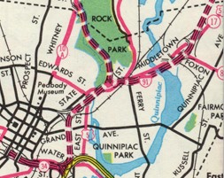
The yellow expressway is I-95 (the Connecticut Turnpike). Yellow roads, like the Turnpike and the Merritt Parkway, were toll roads. (Tolls were discontinued in 1985).
The proposed freeway through [East] Rock Park was to connect to Route 10A. But a few years later, the idea was abandoned.