The Map Inside: Connecticut Officials: 1938
This exhibit shows how the Connecticut official tourist map has changed since the 1930s. You can start with the introduction or browse year to year. The scans may not be actual size (150 dpi), but are consistent with each other.
Other years:
1930
1934
1935
1938
1941
1942
1943
1949
1952
1955
1956
1957
1959
1960
1961
1963
1965
1971
1972
1975
1989
1998
2000
2001
2002
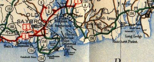
State maps did not include city insets until 1941, so we instead show a double-wide main map sample of the Old Saybrook area.
Instead of route numbers printed alongside the roads (see 1934 map), the 1938 map uses numbered markers overlaying the roads, as almost all American maps do today. Otherwise, the map background and the color inks denoting road classification (trunk line, state aid, improved, and unimproved) remain the same as in 1934.
Aside from the construction of the Connecticut Turnpike (1958) and the Route 9 expressway (c. 1965) the highway layout has not changed drastically in this area.