There are over 200 "secret" routes in Connecticut: highways with numbers above 400. "Secret" is just an unofficial term for unsignposted state roads and state service roads. Many of these are small auxiliary roads, or even long exit ramps.

The general public should never hear about secret routes, but they sometimes show up on maps, and a few road signs have even gone up.

This page discusses some of the more interesting routes in the 500s.

See also: selected 400's, 600's, 700's, 800's, 900's, or the complete list (400-999).

alt_text
  • Length 0.51 miles
  • From I-84 exit 56
  • To Governor Street, E. Hartford

SR 500 was to be the start of a proposed I-284 freeway, leading from the "Mixmaster" interchange at I-84 and Route 2 to a trumpet interchange at I-291 in South Windsor. Related plans even called for extending a US 5 freeway all the way north to I-91 in East Windsor.

SR 500 opened in late 1965 when the "Mixmaster" was completed, and signed only for its destinations: either I-84 and Route 2, or Governor Street and East Hartford.

In 1976, after both I-284 and I-484 were approved for the Hartford area, the SR 500 designation was changed to I-284. Though we split hairs to make the claim, we can say that I-284 did exist for a while and was even open to traffic. However, it was only a half mile long, and never signed as I-284.

On Sept. 16, 1983, I-284 was officially cancelled, and the designation of this short freeway (or long exit ramp) reverted to SR 500.

alt_text
  • Length 0.77 miles
  • From I-84 exit 43
  • To Park Road, W. Hartford

SR 501 is a short freeway once planned to continue north to Farmington Avenue; called the "Trout Brook Connector," it would have been one of several spurs to I-84 in metropolitan Hartford.

To my knowledge, it has never (even in planning) been given a number other than 501. Presumably had it been built, a state route number under 400 would have been chosen for signage -- or, if the FHWA had approved it, an interstate highway number. Federal interstate highway funding fo I-84 at the time covered the highway itself, interchange ramps, and short connectors (about a mile or less); longer connectors were considered separate highways. In 1963, Rep. Emilio Daddario filed a request to add SR 501 to the interstate highway system, along with "a number of short stretches of highway in Connecticut." (The article doesn't list them.) The request was not granted.

Engineers started planning the expressway network around Hartford in the 1940s. By the early 1950s, the consensus had the major east-west expressway (now I-84) passing near Corbins Corner on the way to New Britain, well south of West Hartford Center. To serve that location, a Farmington Avenue Connector, paralleling Trout Brook Drive, was proposed. The portion of I-84 that turns directly south after exit 43, then veers west again near New Britain Avenue, is recognizable in planning maps from 1955.

On Sept. 3, 1965, SR 501 opened to traffic, along with a section of I-84 from Route 71 in West Hartford to Prospect Avenue in Hartford. Though the three-level interchange and short freeway were designed to extend further north, a lack of federal funds led the state to temporarily end SR 501 at Park Road.) The freeway was to be elevated and cross Farmington Avenue to end at Milton Street, at a cost of about $10 million.

In 1968, however, the state highway department said SR 501 could no longer be built exactly as planned because the "lane design and weave patterns" were no longer acceptable for modern traffic. West Hartford's mayor and state senator discussed other changes (now that SR 501 was no longer cast in stone), including shortening the route to south of Farmington Avenue.

In late 1970, open space concerns prompted officials to propose a lower profile roadway, at grade and ending at Farmington Avenue.

In 1975, the state planned to extend SR 501 to Farmington Avenue. Design was already complete, and construction expected to start soon, but the environmental impact statement status was "negative, pending."

At some time after that, the idea was abandoned.

501 Sources

alt_text
  • Length 6.31 miles
  • From Route 2, E. Hartford
  • To US 6, Manchester

SR 502, better known as Silver Lane and Spencer Street, is a busy four-lane arterial road serving retail and offices in East Hartford and Manchester.

502 History

Silver Lane follows an old Indian trail that linked a settlement at the confluence of the Hockanum and Connecticut rivers to the eastern uplands. In East Hartford, Silver Lane was formally surveyed and constructed in the early 1700s -- one of the first such roads outside the village center at Main Street.

20th century history

For decades, Silver Lane was a signed route. From about 1926 through 1931, it was called Route 317; in 1932, it became part of a cross-state Route 101. In 1935, much of Route 101 became part of the new US 44, including Silver Lane.

In 1942 or 1943, following the 1942 opening of the Charter Oak Bridge, US 6 was rerouted over the bridge and onto Silver Lane. US 44 was moved to Burnside Avenue, where US 6 had been. When the Wilbur Cross highway was extended to Vernon in 1949, US 6 was rerouted to stay on the new highway until the US 44 interchange in Manchester.

After US 6 was moved, Silver Lane picked up the "secret" route number SR 810. In 1963, the numbering scheme was changed, and Silver Lane became SR 502.

SR 502's original west end was Main Street (US 5) in East Hartford. When the Charter Oak Bridge was replaced in 1991, the cloverleaf interchange with Main Street was revised. Silver Lane was extended to meet Route 2 and provide access from Route 15 to Main Street.

The intersection with Roberts Street (SR 518) in East Hartford has been traditionally congested. Nearby on Roberts Street is an interchange with I-84; on the other side of Silver Lane is the entrance to Pratt & Whitney, which once employed 30,000 people. In 1968, the state studied grade separating Silver Lane and Roberts Street and building an interchange, but no work was done. Lately, plans have been revived just in case Rentschler Airport and other property on Pratt & Whitney grounds are converted to retail or entertainment use. A football stadium for the University of Connecticut opened on August 30, 2003. (UConn defeated Indiana 34-10.)

502 Sources

alt_text
  • Length 0.57 miles
  • From Sisson Avenue, Hartford
  • To I-84 exit 46, Hartford

SR 503, the Sisson Avenue Connector, resembles an overgrown interchange with some unused stubs. Once planned for a Route 189 freeway, the ramps are now in danger of being torn down. The 1999 "Hartford West" transportation plan included some safety and flow improvements on I-84, including a "reduction in profile" of the interchange. The left exit from I-84 eastbound does not help its case, as left exits are now deprecated.

In late 2000, ConnDOT initiated the West Side Access Study, examining four interchanges including Exit 46, SR 503. The favored alternative as of late 2001 is a single-point urban interchange (SPUI).

For more information about the canceled 189 freeway and SR 503's role in it, see: Woods River Expressway.

alt_text
  • Length 0.70 miles
  • From Flatbush Avenue, Hartford
  • To I-84 exit 45, Hartford

Also known as the Flatbush Avenue Connector, the 2-lane SR 504 freeway shows signs of greater plans for it in the 1960s: a complete interchange with I-84, and a southeasterly extension to US 5 and Route 15 near the point where they merge with the Berlin Turnpike.

504 History

In the 1950s, this route was planned as a Newington Avenue (Route 176) connector to the East-West Expressway (which became I-84). Studies recommended extending it to the Berlin Turnpike as stated above. Together with the planned Woods River Expressway, it would create a north-south freeway from Wethersfield to Bloomfield.

In 1961, both the Woods River and Newington Avenue Connector highways were planned to be part of the relocated Route 9. In 1963, however, the state proposed SR 504 as the Cedar Ridge Connector (no number), leading from I-84 in Hartford to Route 15 in Wethersfield. The short expressway would include an interchange with a Route 71 expressway leading to New Britain.

504 Future

Exit 45 is currently an incomplete interchange, with ramps only for I-84 WB to SR 504 (left exit) and SR 504 onto I-84 EB. The "West Side Access" plans (circa 1999) for the region include completing the interchange, providing access to points west, and moving a ramp to eliminate the left exit. Instead of creating a fully directional interchange, the state might build a diamond interchange or variant, and possibly open up surface access from the north.

504 Sources

alt_text

SR 506 was a 1.90-mile connecting freeway from Route 72 in New Britain to Route 175 in Newington. It was once intended to connect Route 72 to I-291. Now it is part of Route 9.

In 1959, the freeway plan for New Britain envisioned a three-way interchange near downtown, with Route 72 leaving to the west and south, and Route 71 heading northeast. Shortly afterward, Interstate 291 was added to the regional plan, and Route 71 would still function as a connector from Route 72. By the end of the 1960s, the Route 71 freeway was cancelled, but the short connector would be retained, with no signed number of its own. In 1969, the designation SR 506 was given to this route, still just a line on planning maps.

On Nov. 22, 1978, Route 72 was completed through downtown New Britain, along with a short distance of SR 506. Designed to handle traffic between Route 72 and I-291, SR 506 was 10 lanes wide; since it didn't connect to anything yet, it was closed to traffic. New Britain mayor William J. McNamara, irked at the delays in starting I-291 construction, called SR 506 the "road to nowhere;" the state had to keep taking down "Next Exit - Road to Nowhere" signs that cropped up along Route 72. The official signs for SR 506, including "To I-291" markers, were covered up for future use.

The following year brought more bad news for Mayor McNamara: in March 1979, the southwest quadrant of I-291 was cancelled. However, SR 506 would not be thrown away. Instead, a new plan for the Central Connecticut Expressway would link together I-91 in Cromwell, Route 72 in Berlin and New Britain, and the "Stack" interchange in Farmington with about 7 miles of new freeway, creating a bypass functionally similar to the proposed I-291.

On July 17, 1986, SR 506 was extended 1 mile north to Route 175, at a cost of $12.3 million. The 1.90-mile freeway was signed "To Route 175" from the south, and "To I-84 and Route 72" from the north. Near the East Street underpass is the point where old SR 506 and new SR 506 meet, and it's hard to miss: the old section is 10 lanes wide, and the new section is 4 lanes. The freeway also shed its informal "Road to Nowhere" nickname for the title "Taras Shevchenko Expressway", after a Ukrainian poet and freedom fighter.

On Dec. 21, 1989, when Route 9 between I-91 and the Berlin Turnpike opened, the Route 9 designation was extended through New Britain to Route 175, replacing some of Route 72 and all of SR 506. On Sept. 30, 1992, Route 9 was extended to the "Stack" interchange at I-84.

506 Sources

alt_text
  • Summary a 1.04-mile freeway in New Britain, now part of Route 9
  • From Route 9 at SR 571
  • To Ellis Street, New Britain

SR 507 lived 9 years as a freeway connector from the old Route 72 into New Britain, awaiting the completion of the rest of Route 72 through the city. On today's maps, this is the portion of Route 9 leading north from the interchange with SR 571, the Willow Brook Connector, to Ellis St.

When the Kensington Bypass opened in 1962 and was designated part of Route 72, plans were already in place to relocate Route 72 into downtown New Britain. On August 14, 1969, SR 507 opened as part of that future route. From Ellis St. it was signed as "To Route 72 East"; from Route 72, it was probably signed "To Ellis St." (In 1970, SR 512 opened to traffic as another part of Future Route 72, heading east from I-84.)

On Nov. 22, 1978, Route 72 was completed through downtown New Britain, absorbing SR 507 and SR 512.

507 Sources

alt_text
  • Length 1.82-mile freeway
  • From Route 4, Farmington
  • To I-84, Farmington

SR 508 is the short freeway connecting to I-84 exit 39 in Farmington. It was once planned for a segment of Route 4 freeway leading from I-84 to a planned Route 10 freeway. The connector mainline is only about a mile long, but the official length includes 0.8 miles adjacent to I-84 eastbound. This is the stretch walled off by Jersey barrier, so that SR 508 left-hand entrance traffic doesn't cross I-84 to the right-hand Route 9 exit.

Believe it or not, SR 508 was even shorter when it first opened: the terminus was not at Route 4, but at Patrick Flood Road. The familiar reason: federal funds ran out. On Dec. 15, 1972, the extension to Route 4 opened to traffic.

508 Sources

alt_text
SignMaker mockup of SR 533 BGS, I-86
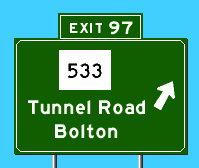
SignMaker mockup of SR 533 sign goof on I-86 circa 1982.

At its interchange with I-84, SR 533 is marked Tunnel Road. In the early 1980s, however, someone involved with the signing contract for reconstruction of Interstate 86 (now I-84) must have read a planning map too literally, and guide signs were actually installed with "Route 533" markers (see rendition to right). Sadly, someone noticed the mistake and it was corrected, and I never got a photo.

How did Tunnel Road get its name? For a one-lane tunnel on the route, built between 1846 and 1849. The 108-foot keystone arch tunnel, the longest in the state, was built with only the help of oxen and hand tools. The arch was built by leaning stones against a temporary wooden frame. When the keystone was placed, the arch became self-supporting. The tunnel is 14 feet wide and 16 feet high at the center. For more information, see http://www.vernonct.com/tunnel.htm.

alt_text
SR 540 sign in East Granby
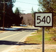
Short-lived "sign goof" exposes SR 540 to motorists circa 2000.

This unassuming 1.43-mile route, known locally as Hatchett Hill Road, connects Routes 187 and 189 in East Granby. SR 540 would be another unremarkable secondary road except for the gorgeous marker sign at roadside near its intersection with Route 187.

The photo, at right, was contributed by a Connecticut resident who prefers not to be named. But thanks: this was quite a find! (The sign was taken down in 2004.)

Another wrinkle: road signs at each end (and the AAA map) spell "Hatchett" with only one trailing T.

540 Sources

alt_text

SR 565 is Maple Ave and Dowd Ave in the Collinsville section of Canton. Part of it near Canton Village along the Farmington River is a state scenic byway; since the official DOT state map and other sources refer to this unsigned route as simply "Route 565," I figured I'd better tell you where it is.

alt_text

SR 571 is a short freeway in Berlin with a complete interchange at Route 71 and an incomplete interchange with Route 9. It's lightly traveled these days and a good illustration of early 1960s highway construction. If it didn't already exist, there would not be a stampede to have it built.

SR 571 is part of the Kensington Bypass, a four-lane freeway that opened on Nov. 1, 1962, leading from Farmington Avenue to the Berlin Turnpike. It was originally signed as part of Route 72. In 1978, when Route 72 was completed through New Britain, the portion bypassed by the new Route 72 was designated Route 372. In 1990, Route 372 was moved to Farmington Avenue (the original Route 72 before the Kensington Bypass had opened), and the leftover freeway became unsigned SR 571. On Route 9, the exit to SR 571 is marked as leading to Route 71 and Route 372.

alt_text
  • Length 0.60 miles
  • From I-84 exit 29, Southington
  • To Route 10, Southington

SR 597 is not much more than a pair of long exit ramps to and from points east on Interstate 84 in Southington. Most drivers know it only as Exit 29 (Route 10, Cheshire) and a left exit at that. It opened on April 26, 1963, at a reported cost of $602,356.46. (One pictures the contractor handing the DOT back $3.54 in change.)

As you exit I-84 on this connector, you can see that it was meant to continue across Route 10. This would have been a Route 10 expressway leading to New Haven. That plan was cancelled around 1974.

In the late 1990s, the state planned to eliminate SR 597 entirely as part of a project to widen I-84. A successful grass-roots support to save it earned Exit 29 fame as Connecticut's "best-loved exit."

597 History

Extending SR 597

In 1963, plans were already in place for a Route 10 expressway extending from New Haven to Massachusetts. In Southington and Plainville, Route 10 would overlap with I-84. SR 597 would be the southern interchange of these expressways.

The Route 10 proposal faded in the early 1970s; in 1974, a state feasibility study determined that building a Route 10 expressway south of I-84 was "not considered a prudent or acceptable alternative, considering social, economic and environmental factors." Meanwhile, the state was studying a short (2-mile) extension of SR 597 to the proposed Route 66 expressway (now I-691). A 1971 report described Routes 66 and 597 as four-lane freeways with wide medians, connected by a multidirectional interchange. Three businesses and 30 homes would be taken.

The 1975 state master transportation plan also recommended extending 597 to 66, this time with ramps to and from the east only; the proposed cost was about $11.5 million.

The SR 597 plan was dropped in early 1976, though there was discussion of reviving it later that year: the advantage would be a simpler interchange at I-691 and I-84. The local Federal Highway Administration (FHWA) office understood that the state Department of Environment Protection (DEP) had blocked the project in 1972; however, the DEP replied that it had no negative information on SR 597 in its files and would review a revived proposal. (An August 1976 Hartford Courant article repeatedly calls the proposal "I-597".)

Although the Route 66 freeway was completed in 1989 as I-691, SR 597 was never extended.

Save Exit 29!

In 1998, the state detailed its plans to widen Interstate 84 between Waterbury and Southington to six lanes, relieving congestion on an old four-lane section of the road. The most controversial part of this otherwise well-received proposal followed from the expense needed to reconstruct the SR 597 bridge over eastbound I-84: to save costs (and eliminate a left exit), the state planned to eliminate the exit.

Local residents and businesses contested that Exit 29 worked quite well the way it was, and the alternatives took more time and diverted traffic on local roads. For a while the state stood firm on removing the exit, but in late 1998 relented. I-84 was widened (though not without other controversies), and exit 29 remained.

597 Sources

alt_text
  • Length 0.67 miles
  • From Pulaski Circle, Hartford
  • To I-91, Hartford

SR 598 is the Whitehead Highway in Hartford; the "Capitol Area" freeway off I-91. There are two partial interchanges in addition to the 3-level interchange at I-91. Built on the bed of the Park River, which was put in a culvert, SR 598 tunnels under the Hartford Public Library. It was intended to be part of I-484, which would have tunneled under Bushnell Park and connected to I-84 at exit 48.

The original Conland Highway, dating back to late 1945, included what is now I-91 south of it the Charter Oak Bridge, and Route 15 from there to the Berlin Turnpike. It was originally called the South Meadows Expressway, and part of US 5 and Route 9.

SR 598 passes under Connecticut's oldest bridge carrying one roadway over another: the Main Street Bridge was built in 1832. Was this an extreme case of planning ahead for a highway that opened in 1945? Not really; until SR 598 covered it up, the Main Street Bridge crossed the Park River.