

From one end of Route 113 to the other is about 4 miles by helicopter; following the U-shaped complete route around Igor Sikorsky Memorial Airport is about twice as long. Here's how to follow it:
- Take I-95 northbound exit 30 and turn right onto Lordship Boulevard, marked as Route 113 North, even though you are traveling southeast.
- See the airport on your left and marshes on your right as Route 113 North turns briefly southwest, then south.
- Turn left (northeast) on Oak Bluff Avenue, until you reach a traffic circle that's the center of a small radial street grid for the neighborhood of Lordship.
- East on Prospect Drive. If you miss your turn, you'll run out of land.
- North (!) on Stratford Road. For the first time, Route 113's cardinal direction is truthful.
- Stratford Road becomes Main Street and turns northwest. If it turned west, Route 113 would hit all points of the compass.
- Main Street turns north, underpassing I-95 with no interchange (but this is I-95, another interchange is never far away) and continues quite conventionally to its end at Route 110.
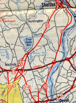 This 1949 map scan shows the historic alignments of routes 8 and 65 south of Shelton and Derby. Route 113 extends along today's Route 108 to Route 65A.