

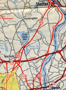
 This 1949 map scan shows the historic alignments of routes 8 and 65 south of Shelton and Derby.
Route 65 was the original highway from Bridgeport to Shelton, which is now served by the Route 8 freeway. In the 1920s, the road was known as State Highway 316; Route 8, which existed as a New England Interstate Route laid out in 1922, instead followed an eastern route to Stratford.
In 1932, SH 316 became Route 65, whose definition was about 9 miles long:
- Huntington Turnpike, from Route 127 in Bridgeport to Nichols Avenue in Trumbull
- Nichols Avenue, to Shelton Road
- Shelton Road in Trumbull and Bridgeport Avenue in Shelton
- Center Street, north to end at Howe Avenue (which was Route 8 at the time)
The 1944 and 1947 highway logs list Route 65 at 9.66 miles, starting at Boston Avenue (US 1A at the time; now US 1).
Nichols Cut-off and Route 65A
In 1940, state planners were exploring options to improve travel between Waterbury and Bridgeport. Residents in the Nichols section of Trumbull protested a planned in-place widening of Route 65 through their town center.
In 1941, planning began on the so-called Nichols Cut-off, a 2-lane limited-access road bypassing the center of Nichols (Shelton Road at Nichols Avenue) to the east.
In 1944, the new road opened: it started at Huntington Turnpike south of Beardsley Parkway, crossed Nichols Avenue at-grade, crossed the Merritt Parkway at a 5-ramp interchange, crossed Woodcrest Avenue at-grade, and joined Bridgeport Avenue north of Huntington Street in Shelton. There are no traces of this road now; the Route 8 freeway is in its path.
Route 65 was moved to the new road; the older route through Nichols became Route 65A.
As plans for a Route 8 freeway emerged in the late 1940s, it was decided to send Route 8 to Bridgeport instead of Stratford. Route 65, in the crosshairs of a very large gun, became part of the relocated Route 8 on Dec. 17, 1951, the day the Commodore Hull Bridge opened for Route 8. Route 65A was also renumbered on that date.