Updated Feb 13, 2024
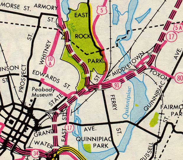
The East Rock Connector was a controversial freeway proposed to link Whitney Avenue at Armory Street in Hamden to I-91 exit 6 in New Haven. The four-lane roadway would pass through East Rock Park and run along both banks of a rechanneled Mill River. The complex interchange at I-91 exit 6 (Willow Street / Blatchley Ave) was built to accommodate the proposed Connector.
The Mill River meanders northward next to a 380-foot traprock ridge that gives East Rock Park its name. In 1942 New Haven city planners first considered locating an arterial road here, and this was "intermittently considered" into the 1950s.
In 1956 the location of Interstate 91 north of downtown New Haven was under study, and the original proposals included an eight-lane freeway through part of East Rock Park into Hamden. I-91 would tunnel under East Rock in the same manner the Wilbur Cross Parkway tunnel was constructed under West Rock in 1949.
In 1957 it was decided to shift I-91 to the east (as it was eventually built, swinging from State Street over to Middletown Avenue), and a smaller-scale four-lane connector was proposed to provide access from Whitney Avenue. In 1958, a study by the Quinnipiac Valley Development Corp. stated that the connector would be essential for adequate traffic service regardless of where I-91 would be located.
In public hearings held in August 1959, both the I-91 and East Rock Connector plans were deemed "generally acceptable."
 The proposed East Rock Connector (no number, but it's the one running through the park.) From the New Haven inset of the official Connecticut highway map in 1964. I-91 (also a dotted line) opened here in 1966. Map copyright © Connecticut Highway Department.
The East Rock Connector would be a four-lane freeway starting at I-91 exit 6, and a partial cloverleaf for shared access to Willow Street. Continuing north, the opposing roadways would be on opposite banks of the Mill River, which would be straightened and channeled. The reasoning here was that having both roadways on one side would consume too much right of way. North of Orange Street, the northbound lanes would cross the river to join the southbound lanes, and the connector would terminate at Whitney Avenue (former Route 10A) and Armory Street. There would be no interchanges between Willow Street and Whitney Avenue.
The highway would have been 50% federally funded and 50% state funded as a connector to the interstate highway system. In 1964, the estimated cost was about $5 million, but quickly grew to about $10 million. I've seen no record of any proposed route number for the connector; my earlier "Route 10A" supposition hasn't been reflected in any of the sources. There were also no reported plans in the 1960s to connect this highway to the proposed Route 10 freeway.
In 1959 and 1960, all parties seemed in agreement over the general purpose and location of the connector. But a few years later, the East Rock Connector became a flashpoint in controversy between city officials, residents, and park groups, who called it a waste of good park land, and the state highway department, who called it an integral part of the state highway system.
The New Haven Register led the charge that the state was trying to steamroll its wishes against those of the people the highway would harm. Though the Register favored some new highways such as a Route 34 extension to the Maltby Lakes area, it was adamantly opposed to the East Rock plan. In 1964 State Rep. Lawrence O'Brien contended that instead of relieving traffic on local streets, the connector would instead concentrate traffic at its northern terminus.
In 1965, the state General Assembly enacted paragraph 7-131j of the General Statutes, which dictated that the State cannot take municipal park land (such as East Rock Park) for a highway unless the city's Board of Aldermen approve the proposed taking by a majority vote of all of its members. This made the Connector much less of a fait accompli.
In 1967, the state highway department sought a state allocation of $5 million for the 1969-1971 biennium, to avoid losing $4.5 million in federal matching funds.
The East Rock Connector proposal was dropped around 1970.