Old Route 78, Windsor Locks
The old Route 78 was assigned in 1935 to Elm Street in Windsor Locks, running 2.28 miles from Route 75 to US 5A (now Route 159). One block north, Spring Street, was part of Route 20, and a short distance north of that, North Street, was Route 76, also designated in 1935.
In 1951, the state apparently decided that signing 20, 76 and 78 was a bit much, and demoted routes 76 and 78 to SR 524 and SR 523 respectively. In 1962, Route 140, which had taken over from Route 20 the previous year, was moved from Spring Street to Elm Street (the original Route 78).
New Route 78, Stonington
In the 1960s, a proposed Route 2 freeway from Norwich to Stonington was added to the state's freeway plan. The remainder of Route 2, from Norwich to Hartford, was already planned as a freeway, and by the late 1960s much of it was complete. Scattered references to a "Rhode Island expressway" denote the planned upgrade of Route 2 east of Norwich.
The idea of a bypass around the Rhode Island city of Westerly surfaced in the 1960s. By 1966 this had clarified (and was made public) as the Westerly Bypass, a limited-access road leading from I-95 in Connecticut to US 1 near the Westerly State Airport in Rhode Island. The 1966 plan was a two-lane road (scaled down from four lanes to lower its cost), with a price tag of $3.5 million, to open in 1968.
In February 1967, a corridor hearing for Route 2 in the Stonington area was held, to present a general location for the highway. That segment of the new Route 2 would run eastward from Interstate 95 to the Rhode Island state line just south of White Rock Road, and continue as the planned Westerly Bypass after that.
Between the 1967 corridor hearing and the design hearing in 1970, the states decided to avoid confusion about the existing and proposed Route 2's by renaming the proposed expressway to Route 78. Rhode Island's projected opening date in 1968 came and went, with the route still under study.
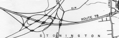
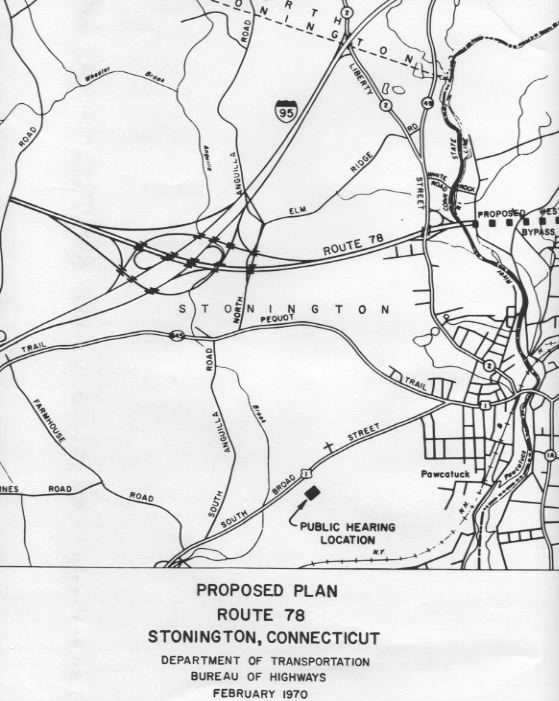
In February 1970, Connecticut conducted a design hearing, showing the specific location for the road and estimated schedule for construction. The final configuration would be a four-lane expressway from the state line to I-95, including an interchange at Liberty Street (existing Route 2). A full freeway interchange at I-95 would be built, including provisions for continuing Route 78 toward Norwich.
However, Route 78 would be built in stages. At first, a single bridge over the Pawcatuck River would be built, with ramps to and from Liberty Street. An overcrossing for Liberty Street would be built, and some excavation done west of there to prepare for future construction and provide fill for the river bridge.
In the next stage, a parallel span would be built over the Pawcatuck River, to the south of the first stage bridge. Then Route 78 would be extended westward as a divided highway to I-95 just west of North Anguilla Road. The interchange at Liberty street would be completed with two additional ramps.
After a full interchange with I-95, Route 78 would have continued toward Norwich (Feb. 1970 drawing; see
larger picture).
At Interstate 95, only two of that interchange's eight ramps would be constructed at this stage: from Route 78 to I-95 southbound, and from I-95 northbound to Route 78 east. There was no funding for this stage yet, but it was hoped to obtain funding and begin construction by 1973. The 1975 Master Transportation Plan included a projected cost of $12.8 million for this stage.
In the future, the I-95 interchange would be made complete and Route 78 extended toward Norwich. This project was not part of the Stonington area design.
What really happened
Land condemnation for Route 78 began in 1969; construction began in 1972. On Dec. 17, 1975, Route 78 opened as a modified stage 1 proposal: a 2-lane controlled-access highway (known as a "Super 2") from a half-interchange at Liberty Street (Route 2) eastward into Rhode Island. An overpass for Route 2 was built, wide enough for an eventual four-lane Route 78 freeway; and some excavation was done to the west. On the east side, an overpass over US 1 had been planned, but was scrapped when a highway bond issue was defeated. Route 78 ends today at a signalled intersection with US 1.
The configuration differed in two ways from today's Route 78: at the interchange with Route 2, and the divider between opposing traffic lanes.
At Route 2, the westbound offramp joined Route 2 further north than it does today, and there was no direct onramp from Route 2 eastbound. The intention was to, as funds became available, extend Route 78 to I-95 within a few years. In 1979, as the prospect of a completed Route 78 was dimming, ConnDOT planned a more immediate fix to address congestion at the interchange. Using the already-constructed Route 2 overpass over future Route 78, a new ramp from Route 2 eastbound directly to Route 78 eastbound would thread under the bridge. This was done circa 1983. At the same time, the ramp from Route 78 westbound was moved south, to avoid interfering with the new onramp.
While the interchange was revised for safety, Route 78 itself was modified, twice, for safety. The highway opened in 1975 with only a double yellow line between opposing traffic lanes. Unfortunately, a number of serious head-on collisions (and four fatalities) marred the first few years of operation. In August 1979, the Rhode Island DOT installed a "chatter strip", which creates a loud noise when vehicle tires cross, to let drivers know when they were straying over. (A year earlier, ConnDOT had installed temporary dividers at the Route 2 interchange after a fatal accident occurred there.)
The "chatter strip" installed in 1979 may have saved some lives; but an August 1980 accident claiming a mother and her two children prompted highway officials to install the Jersey barrier Route 78 has today. This was done in April and May 1981.
Route 78 was never completed to I-95. Federal funding grew scarce as the 1970s progressed. In 1983, the state included an extension to I-95 on its "wish list" to be funded from the $369 million "trade-in" money available from cancelling I-84 toward Providence. However, the combined cost of the project wish list already exceeded that amount.
With increased tourist traffic in the late 1990s, dusting off the Route 78 plans might have made sense; however, the state opted for the more expedient solution of widening Route 2 to four lanes between I-95 and Route 78. This was completed in July 2001.
Long Island Bridge might have involved Route 78
One of the historical alternatives for a highway crossing of Long Island Sound was a proposed bridge from Orient Point, N. Y. to Watch Hill, R. I. If this were built, it probably would have extended I-495 over the Sound and connected to RI 78.
Then RI/CT 78 would have almost certainly been upgraded to four or more lanes, extended to I-95 in Connecticut, and become part of I-495.
For more information, see: Long Island Crossings

