Updated Oct 20, 2018
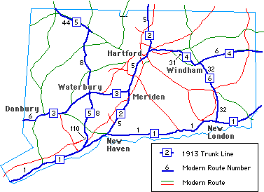
 Map of six trunk lines, as proposed in 1913
In March 1913, a bill backed by the Good Roads Association called for a $5 million bond to build 375 miles of concrete roads over six main trunk lines. The concrete would cost about twice as much as the contemporary macadam resurfacing - about $12,000 a mile - but was projected to outlast macadam roads by twenty times.
Though the trunk lines were numbered, they were not signposted with numbers; no route number signs went up until 1922 with the advent of the New England Interstate and state route system. Here are the descriptions of each trunk line, with equivalent modern routes added:
"From the Connecticut State line in East Portchester through Greenwich, Stamford ... to New Haven by the lower or shore road by way of Savin Rock, to East Haven ... New London ... to the State line at Westerly, R. I."
This is almost all US 1 now, except for the route between Milford and New Haven, which roughly runs along Route 162 and Route 122, closer to the shore.
"From New Haven to North Haven by way of the Middletown Ave. route, Wallingford, Meriden, Berlin, Hartford, East Hartford, South Windsor, Warehouse Point, Enfield, to the State line in Thompsonville."
This is mostly US 5, save for minor realignments over the years.
"From the State line in Mill Plains to Danbury, to Newtown by the northern or upper route, passing near Hawleyville, Bennett's Bridge, Southbury, Woodbury, Middlebury, Waterbury, Marion, Milldale to Meriden."
This is US 6 from the state line to Woodbury (the "upper route" mentioned is US 6, while the lower route is mostly Route 302), then the old Route 14 from there to Meriden. The old Route 14 in this area is now Route 64, Route 322, and local streets in Waterbury and Meriden.
"From Hartford to East Hartford, Manchester, Coventry, South Coventry, Willimantic, South Windham, Windham, Brooklyn, Danielson, to the State Line in Killingly."
This is US 6 or US 44 (possibly Silver Lane involved) to Bolton Notch, and beyond to Route 31; then Route 31 and Route 32 to Willimantic; then Route 66 and US 6 from there to the state line.
"From Stratford north through Derby to Ansonia ... Waterbury ... Winsted, Norfolk, to the state line in Canaan."
This is the old Route 8 (Route 110 north from Stratford, then local streets paralleling the Route 8 freeway to Winsted), then US 44 to Canaan, and US 7 to the state line.
"From New London on the west side of the Thames River north through Quaker Hill, Norwich, Franklin, to South Windham."
Pretty good description of the modern Route 32 between those towns.