
Updated Dec 12, 2022

The Waterbury Expressway, a term no longer used, was a freeway in the path of today's I-84 from west of Mill Street to east of Hamilton Avenue.
You may have an image in your mind of what it was like: built in the early 1960s; four lanes, narrow and twisty, with a series of diamond interchanges too close together – something suitable at the time but eventually no longer up to the task. It was widened in stages and is now finally six lanes from Route 8 to Hartford.
A lot of Waterbury road history is yet uncovered, but we do know a few things. The first segment of Waterbury's expressway system opened in 1949, is still open to traffic, but is not part of I-84. (Or Route 8.) The rest of it opened in the 1950s, and the original layout was even stranger than anything in Hartford. For one, the eastbound and westbound lanes crossed over each other near where Brass Mill Center is now.
We'll show maps and aerial photos as we dig into a bit of history in eastern Waterbury. To start: a planning map from 1946, depicting future Interstate 84 passing through Waterbury. Route 8 is listed as a proposed distributing route, acting in purpose (if not in name) as a 3-digit auxiliary interstate route.
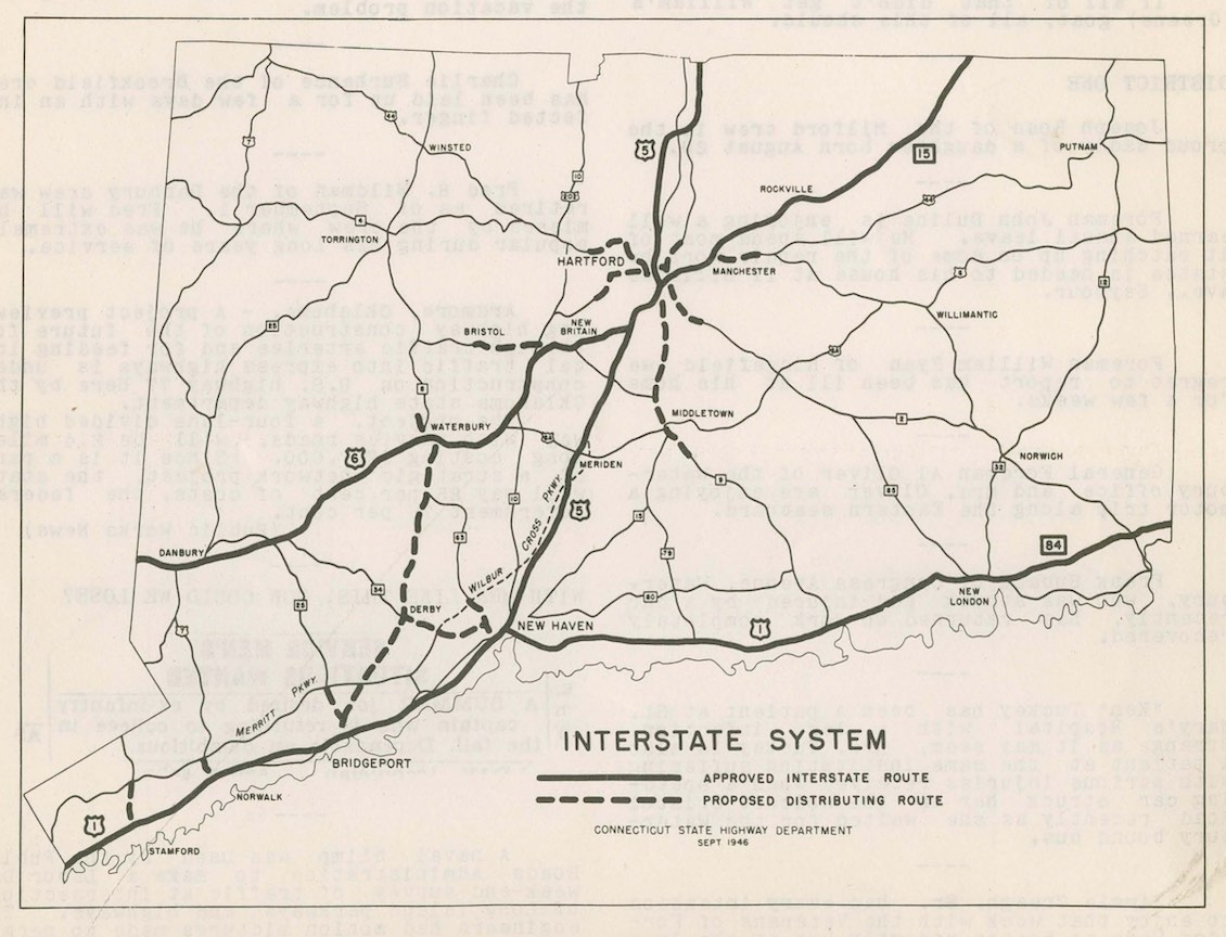 This 1946 map shows the state's planned three main interstates and proposed connectors.
The topography of the area, and the many cities along the Naugatuck River, left few alternatives for east-west travel through Waterbury. In the 1940s, the one thru route was US 6A, following these streets right through the city center:
The city needed a solution for increasing motor traffic leading out of the city to the east, as well as cross-state and interstate traffic; plans for an expressway or two started to form.
This four-lane route, which opened on Dec. 29, 1949, connects Hamilton Avenue to Meriden Road via Hamilton Park. Part of the old Silver Street remains to the north.
This road is part of Route 69 now, and seems an Expressway in Name Only: short, undivided, no interchanges, and a single grade separation at Hamilton Park Road. But it was a start, and would tie in with a planned route along Union Street, to bypass congestion on East Main Street. That might have been the early plan, to terminate the expressway at Meriden Road. However, the Waterbury Expressway would eventually be extended further south and east along the Mad River.
In 1950 this road was designated SR 702 (but not signed); in 1962 it became part of US 6A, and eventually part of Route 69.
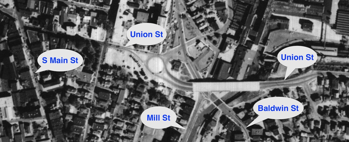
Also in late 1949, work began on the Mill Street Viaduct, a four-lane bridge over Mill Street, Baldwin Street, and the Mad River. Here's a 1951 aerial photo of the finished viaduct, connecting to Union Street on both ends, with a rotary at Franklin Street.
In 1952 the viaduct was designated SR 924, but not signed. In the same year, someone noticed that 924 was already in use for a street in Milford, and changed the viaduct's number to SR 925.
Most of this work was demolished later for I-84 construction.
 This 1951 aerial photo shows an early part of the Waterbury Expressway.
In the mid to late 1950s, the Expressway was extended, now leading from Union Street near South Street, past the Scovill brass factory (now the Brass Mill shopping complex). This was a true freeway, four lanes divided with interchanges, but the design has to be seen to be believed:
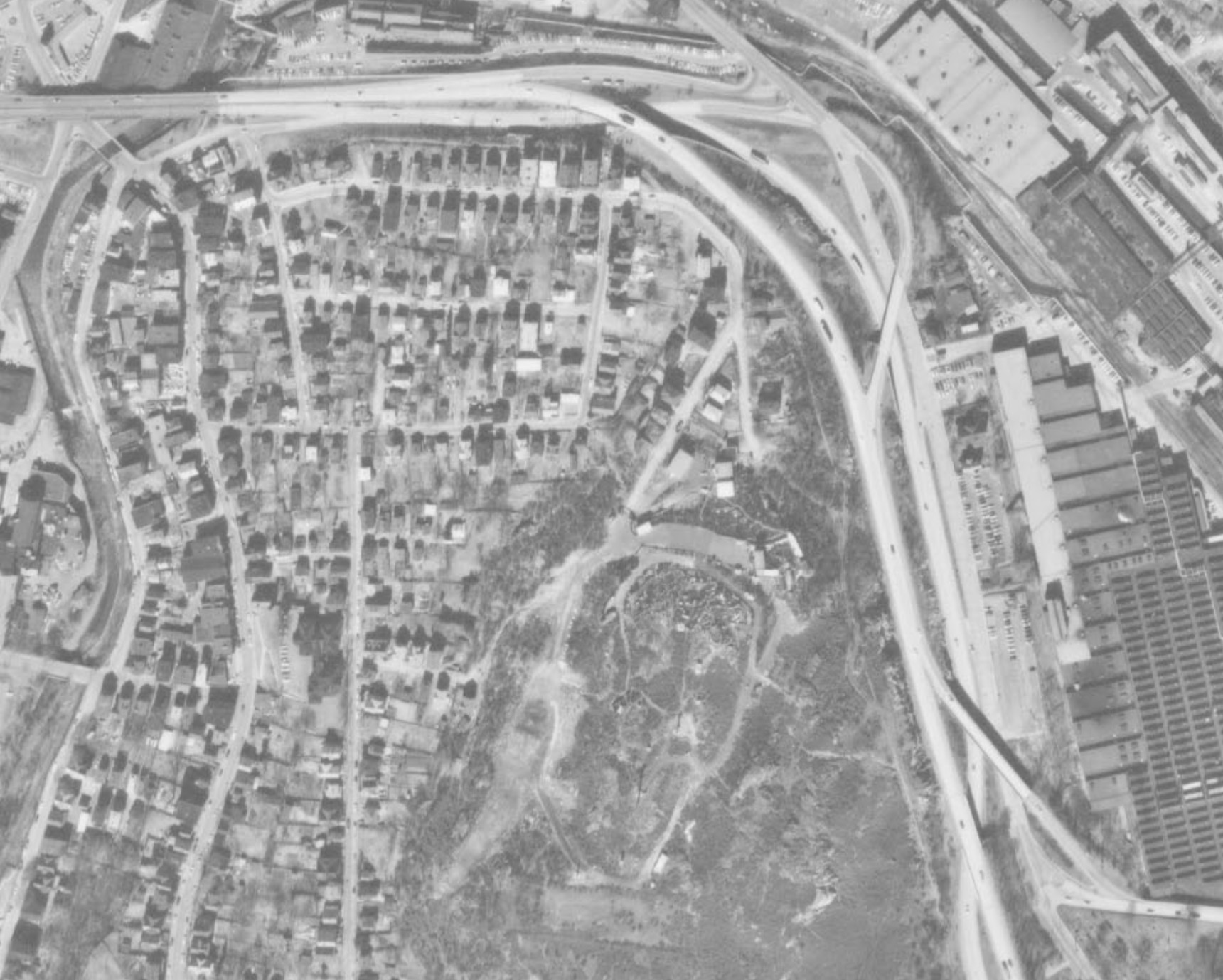 This 1970 aerial photo shows the early layout of the Waterbury Expressway, now I-84.
The eastbound lanes cross under the westbound lanes, to provide left exit and entrances to Union Street. The westbound lanes have right-hand exit and entrance ramps, including a direct ramp from the The Silver Street Expressway – but from the "wrong side of the road."
This design was seen as appropriate for the time, bound by the steep hills to the west and the large factory to the east. Supervising engineers signed off on it.
By the 1960s, though, it was apparent this would need to be fixed. In the 1963 Waterbury Area Transportation Study, widening to 8 lanes was recommended to handle growing traffic.
In a 1971 draft EIS for reconstructing I-84 here, writers were more specific about the deficiencies here:
There are other sub-standard features of the existing highway such as ramps for entrance and exit on the left sides of the roadways, very short distances between on ramps and successive off ramps, reversal of position of the eastbound and westbound roadways at two locations, insufficient sight distance on the mainline to on and off ramps, and off ramps that encourage wrong way entrance because of their position... there have been several fatal accidents caused by drivers entering an off ramp and colliding with vehicles on the mainline.
The Expressway did not have a posted number for several years; instead, the SR 925 designation of the Mill Street Viaduct was extended over it. It became I-84 in 1962.
Around 1973, I-84 was modernized here, creating the 6-lane profile with eastbound collector-distributor lanes we have today. This work erased most traces of the old Waterbury Expressway, including layout of surrounding streets. For example, Union Street, which had been severed by the original expressway, was reconnected.
There's more to find out here. This is what I've been able to find online. Some lingering questions: