Route 262 is used primarily in both towns for its southern access to Route 8. It is generally marked east-west in Watertown, and north-south in Plymouth.
Updated Dec 24, 2024
 |
|
Route 262 is used primarily in both towns for its southern access to Route 8. It is generally marked east-west in Watertown, and north-south in Plymouth.
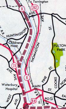
 For a short time, Route 262 followed the old Route 8 into Waterbury, where the new Route 8 freeway temporarily ended. Scan from 1965 official state map.
Until the early 1960s, Route 262 was a series of town roads, not yet a state highway.
By the late 1950s, the Plymouth portion, known as South Street and South Main Street, carried significant traffic between downtown Plymouth and Waterbury. In January 1957, state representatives from the city submitted a bill to have the state take over those streets, extending from US 6 to the Waterbury city line. In a March 1957 meeting of South Street residents, most opposed including it in the state highway system. A few bills submitted died in committee, but on June 19, 1959, South Street from US 6 to the town line was accepted as a state highway: SR 862.
At the time, state representatives in Plymouth were proposing that Waterbury Airport, a small pair of grass runways along today's Route 262 north of Waterbury, be developed into a regional airport. Ultimately, Waterbury-Oxford Airport, with a 5,800-foot paved runway, opened to the south in December 1969.
In March 1961, the state Highway Department announced that Spruce Brook Road in Terryville would be included in the state highway reclassification. On Aug. 20, 1962, the state took over Spruce Brook Road, completing a state-maintained route from US 6 in Terryville to Waterbury Road, which was then part of Route 8. The highway was still called SR 862, and not signposted. On Mar. 4, 1963, SR 862 was given a non-secret route number, and became Route 262.
On Nov. 23, 1964, six miles of the Route 8 freeway opened in the area, from Huntingdon Avenue in Waterbury to Route 109 in Thomaston. The route was not yet complete to the south; Route 8 continued on surface streets into Waterbury, using Huntingdon Avenue and Thomaston Avenue. Route 262 was extended south along Waterbury Road and Thomaston Avenue, former Route 8, to the new alignment of Route 8 at Huntingdon Avenue. The portion of old Route 8 north of Route 262 became unposted SR 848.
On Sept. 20, 1965, another segment of Route 8 freeway opened, extending south to W. Main Street. Two months later, in November 1965, the Highway Department announced more number changes to old Route 8. Route 262 was removed from the Spruce Brook Road to Huntingdon Avenue portion; SR 848 was removed from Spruce Brook Road to Frost Bridge Road. The article doesn't mention Route 262 being extended over Frost Bridge Road into Watertown, but that eventually did happen.
The original freeway plan for Route 8 did not include an interchange at Frost Bridge Road (future Route 262). In August 1961 (and again a year later), at the prodding of local residents and businesses, the state announced a full interchange would be constructed. The decision makes sense considering Route 262's role as a connector to Route 8.
In the early 1960s, the Plymouth section of Route 262 was improved and realigned.
In 1966, work started to widen and realign Route 262 for a length of one mile easterly from old Route 8.
In March 1969, the state announced it would seek bids for a new segment of Route 262 in Watertown, leading from Buckingham Street (Route 262 and SR 855) to Frost Bridge Road. The connector would form "part of a high speed road from [Thomaston] to Waterbury". The 1.5-mile connector was built around 1972, and appears to have no street name other than Route 262. It is three lanes wide, including a climbing lane in the westbound direction. By this time, the definition of Route 262 would be extended over Buckingham Street to US 6 in Watertown.
In 1970, the state Transportation Commission held a public hearing concerning proposed improvements, including realignment, of one mile of Route 262 starting about 0.3 miles east of former Route 8. Work started in August 1975. Aerial photos show an older alignment of Spruce Brook Road (no longer open to traffic) west of the current roadway.
In 1975, the state proposed realigning 0.7 mile of Route 262 (South Street) in Plymouth, between Lake Plymouth and Tomlinson Road. Work began in August of that year.