
Updated Sept 8, 2025
The Arrigoni Bridge, carrying Route 66 and Route 17 across the Connecticut River, connects Middletown and Portland. The steel through arch bridge was the longest of its kind when it opened in 1938.
In the 1960s, state long-range freeway plans called for a new bridge at Middletown carrying a Route 66 freeway. However, these plans were canceled, and the Arrigoni remains an important (though overworked) transportation link in central Connecticut.
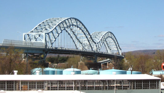 The Arrigoni Bridge, seen here from the north on the Portland side, dominates the local skyline. Photo taken April 2004 by Kurumi.
Go far enough back in history, and the only way to cross the Connecticut River was by ferry. The first service in Connecticut was at Windsor in 1642; in Middletown, service was started in 1726.
On April 12, 1896, a 1,300-foot two-lane plank drawbridge was built at Middletown. At the time, it was the longest highway drawbridge in the world. This is not the same as the swing bridge that still exists south of the Arrigoni and used to serve the Air Line railway; it was probably demolished after the new bridge opened.
As motor traffic increased in the early 1900s, especially on weekends and holidays, drivers clamored for a way to cross the river without being interrupted to let marine traffic pass through. Studies for the new bridge date back to at least 1933, when the state was calling it the Route 346 bridge (State Highway 346 is a 1920s numbering for what is now Route 3 from Cromwell to Middletown).
Construction started in 1936, and continued nearly 24 hours a day until the Arrigoni Bridge opened to traffic on August 6, 1938. The day it opened, the bridge was the longest of any kind in New England. The roadway is 45 feet wide, for four lanes of traffic; and the bridge was designed to allow adding two additional lanes without major modifications. (Perhaps engineering standards have changed; though additional capacity is needed, there is no talk of widening the bridge today.)
The bridge was completely repainted in 1997.
The Arrigoni Bridge is in the middle of an S-curve on Routes 66 and 17. On the Portland side, drivers coming off the bridge can continue on Main Street (Route 17A) or turn right onto a four-lane divided roadway carrying routes 17 and 66.
On the Middletown side, the bridge approach curves down to intersect Main Street and a short connector road to Route 9.
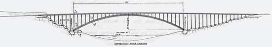 Twin arch spans, like the one shown, would cross the Connecticut River downstream of the Arrigoni Bridge in a 1960s proposal for a new Route 66 freeway. Each 1,120-foot span would carry four lanes of traffic. (larger picture)
In 1963, the state added a 40-mile US 6A expressway to its long-range highway plans. From I-84 in Southington, the freeway would follow today's I-691 and Route 66 eastward to Willimantic. Since the Arrigoni Bridge would not be suitable for such a highway, a new bridge would be needed.
In 1965, the General Assembly created the Middlesex Bridge and Port Authority, to study the feasibility of a new bridge and a port at Middletown. In studying for the bridge, the Authority cooperated with the Mid-State Regional Planning Agency, which was at the time planning the new Route 66. The average daily traffic (ADT) capacity of the Arrigoni Bridge was considered to be 30,000 (and at the time was serving about 20,000 vehicles daily); the planner assigned a need to serve 73,000 ADT in the design year 1995. In that scenario, the Arrigoni would be swamped.
In 1967 and 1968, studies for the new bridge were made public. Two river crossings were studied in detail, both downstream of the existing bridge. Since the river curves at Middletown, the alignment at each crossing would be roughly north-northeast instead of east.
Line A would cross east of Bodkin Rock, roughly south of where Route 17 leaves the 66/17 overlap in Portland. Line B would cross closer to both downtowns, south of the High Street/Route 66-17 intersection in Portland. The preferred alternative was Line A, for lower construction costs.
The bridge itself would be twin arch spans, the design thought best to meet all requirements. Each direction would carry four lanes, although only three would be opened to traffic at first. The main span would be 1,120 feet long, nearly as long as both arches on the Arrigoni, and provide about 160 feet of clearance. Twin single-span suspension bridges was also considered.
The bridge cost was estimated at $31 million, and the recommended date for completion was 1975.
After the new Middletown - Portland Bridge opened, the Arrigoni Bridge would be left open for local traffic. In the area, the Route 9, 17, and 66 freeways would be redesigned to better serve traffic and solve some longstanding problems.
Route 9 would be relocated completely away from Acheson Drive, the substandard surface street along Middletown's waterfront. From Cromwell, the new Route 9 would follow the Route 3 corridor south to the Butternut Hollow area, where it would merge with the new Route 66. The combined highway would continue east, bypassing downtown Middletown to the south. At Tryon Hill, Route 9 would continue along its current alignment, while Route 66/17 would head northeast to the new bridge.
In Portland, Route 66 would split from Route 17 in a 3-way interchange, with Route 17 heading north and Route 66 heading east.
Eventually (probably in the 1970s), plans for both the new bridge and the Route 66 freeway were cancelled.
A proposal has been in the works since the 1990s to decorate the Arrigoni Bridge with necklace lighting and spotlights from below. The cost would be about $500,000. Many oppose this move, saying the money could be better spent elsewhere and that light pollution will further hinder stargazers and astronomers. Supporters say the bridge will look more attractive and support tourism.
In late 2023, the U.S. Postal Service issued a set of four first-class stamps featuring American Bridges:
The stamp art features four bridges completed between 1938 and 2022: the multi-span steel through arch Arrigoni Bridge connecting the Connecticut municipalities of Middletown and Portland; the S-curved cable-stayed Bob Kerrey Pedestrian Bridge between Council Bluffs, IA, and Omaha, NE; the steel truss Skydance Bridge topped by a public sculpture in Oklahoma City; and the basket-handle twin arch Iowa-Illinois Memorial Bridge connecting Bettendorf, IA, and Moline, IL.
Collectors may have a tougher time obtaining one:
The Bridges stamps are intended for business mail users and are sold in self-adhesive coils of 3,000 and 10,000. Use of these stamps requires a special permit and a minimum quantity of 500 letters.